Saturday, June 28, 2008
Early morning thunder
Was anybody else in Uptown Waterloo woken up at 4:30 am on Saturday morning by a particularly loud crack of thunder?
Saturday, June 21, 2008
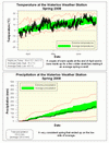
Spring 2008 Summary
A very average spring
Although we had a good stretch of warm temperatures at the end of April and some more at the beginning of June, these were offset by generally cooler temperatures during the rest of the spring. In the end the daily high temperatures were about 0.5 degrees lower than average and the daily low temperatures were about 0.5 degrees higher than average, thus overall it was bang on the average.
After the very wet winter, the spring was on the low side of average coming in at 182.8 mm compared to an average of 220.9 mm. There was an 11 day stretch in April and a 7 day period in May without any precipitation, but apart from those the rest of the spring was pretty consistent.
Summary for Spring 2008:
Maximum Temperature 30.4 °C
Minimum Temperature -14.0 °C
Average Daily High Temperature 15.2 °C (Long term average 15.6 °C)
Average Daily Low Temperature 4.6 °C (Long term average 4.2 °C)
Total Precipitation 182.8 mm (Long term average 220.9 mm)
(Long term averages based on 1970-2000 data for the Waterloo Wellington Airport)
Click on the image below to see the monthly chart:
Wednesday, June 18, 2008
Talking about the weather June 18, 2008
Listen to Carlos Benevides and myself talk on DAVE-FM about the wet weather so far in June and what's ahead in both the short and long term.
Listen to the interview
See Carlos' blog and his countdown to the first day of summer
Listen to the interview
See Carlos' blog and his countdown to the first day of summer
Many days with rain so far in June
The good news is that we haven't had to do much watering in the garden lately.
The bad news is that is has rained on 13 of the first 18 days of June, while typically we only get about 12 days of rain for the entire month.
However the actual total amount of rain so far is running at about average.
The bad news is that is has rained on 13 of the first 18 days of June, while typically we only get about 12 days of rain for the entire month.
However the actual total amount of rain so far is running at about average.
Sunday, June 15, 2008
Big temperature drop
In the 15 minutes between 5:30 pm and 5:45 pm on Sunday the temperature went down by 4.5°C.
That is a pretty big drop, but it doesn't match the UW weather station record which is 5.7°C on June 8th, 2007.
That is a pretty big drop, but it doesn't match the UW weather station record which is 5.7°C on June 8th, 2007.
Sunday, June 1, 2008
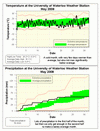
May 2008 Summary
A cold May with just barely average precipitation
It was a cold month, almost 2 degrees below average, with only 7 of the days warmer than average. However, apart from a stretch between the 18th and the 23rd where we had significantly below average temperatures the rest of the month wasn't that far off the average.
We also went for a month without a day over 20 degrees after that great week at the end of April, this combined with the amount of snow we had linger into the spring makes me think that people are desperate to see some more warmer temperatures.
The last recorded below zero temperature occurred at 7:15 am on the morning of May 1st, this is early as the frost free date is typically about a week later. However even in the 10 year history of UW weather station it has happened in late April so it isn't a record or anything.
Thus far this year has been a real mixed bag for temperature: 2 months significantly above average (January, April), 2 significantly below average (March, May), and one in the average range (February).
It started out as a wet month with 47 mm falling in the first half, however it didn't keep up that pace as we only saw 12 mm in the second half. In the end our total precipitation for the month was just barely enough to get into the average range.
We have had pretty consistent precipitation the last few months, while the total for the year (388.9 mm) is still above average for this time of year (340.2 mm).
Environment Canada prediction of temperature for the month: Average
Actual Temperature: Below average
Summary for May 2008:
Maximum Temperature 26.2 °C
Minimum Temperature -2.0 °C
Average Daily High Temperature 16.1 °C (Long term average 18.7 °C)
Average Daily Low Temperature 5.1 °C (Long term average 6.4 °C)
Total Precipitation 59.8 mm (Long term average 75.7 mm)
(Long term averages based on 1970-2000 data for the Waterloo Wellington Airport)
Click on the image below to see the monthly chart:
Subscribe to:
Posts (Atom)


