Here are the final results of the summer of 2008 poll:
51% (108 Votes) It was a great summer, not too hot and the air was mostly clean, wouldn't have changed a thing.
26% (56 Votes) It was good, but I would have liked a few over 30 days and a little less rain.
7% (16 Votes) It was OK, some good days, some bad days, felt like an average summer.
8% (18 Votes) It was bad, the rain got me down.
5% (12 Votes) It was a total washout, too much rain and it never felt like beach weather.
So overall, 75% of you thought it was either a great or good summer. There was certainly a few people who voiced their opinion to me that they didn't like the summer, but obviously they were in the minority.
Sunday, September 28, 2008
Monday, September 22, 2008
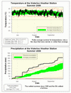
Summer 2008 Summary
A very, very wet summer (5th wettest ever) with slightly above average temperatures
Although we had 46 days with some precipitation compared to an average of about 33 days for a typical summer, most of these storms were intense, short storms that quickly made way to sunny skies. That's why one could call it the "Summer of Rainbows" as there seemed to be a lot of them this year as evidenced by lots of people sending me their pictures. I don't have any number to back it up, but it seemed that there were very few "dreary" days where it rained or was cloudy the entire day.
As this summer contained the greatest single day precipitation in the 10 year history of the UW Weather Station (78.0 mm on July 11) and 4 more days with over 20 mm, it is not surprising that the total for the season (416.2 mm) was well above the average (272.1 mm).
This was the 5th wettest summer since records began way back in 1915. Here are the totals from the summers that beat us: 557.0 mm (1915), 452.2 mm (1987), 430.9 mm (1940), and 423.7 (1988).
**Special note on the 1915 total, a lot of that came from the single wettest day on record in the area, August 4th, 1915, when a spectacular 175.3 mm is reported to have fallen. I am a bit sceptical about that number, however although only 42 mm was reported in Guelph, there is a reading of 126 mm that day in Toronto. If anybody has the time to check out local newspaper reports from around that time I would love to know what they said about that storm as it would have been an incredible amount of rain.**
For only the second time in UW Weather Station history, we did not see a single temperature above 30 degrees during the entire summer (the only other time this happened was in 2004). However, that didn't mean it was a cold summer as the overall average was 0.5 °C warmer than average for the season. The temperature was pretty consistent as there were only 2 days that were more than 5 degrees colder than average and 4 days that were 5 degrees warmer.
The air was pretty clean throughout the summer with only one day that actually registered "poor" air quality (July 18th) according to the Ontario Ministry of the Environment website.
Summary for Summer 2008:
Maximum Temperature 29.9 °C
Minimum Temperature 4.8 °C
Average Daily High Temperature 24.3 °C (Long term average 24.3 °C)
Average Daily Low Temperature 13.4 °C (Long term average 12.3 °C)
Total Precipitation 416.2 mm (Long term average 272.1 mm)
(Long term averages based on 1970-2000 data for the Waterloo Wellington Airport)
Follow this link to see the graph showing the temperature and precipitation:
Sign up to get the monthly weather station summary by e-mail
Friday, September 19, 2008
What did you think about this summer?
Perhaps you thought there was too much rain this summer, maybe you wanted some really hot temperatures?
Or are you on the other side and think it was a perfect summer with moderate temperatures and clean air?
Have your say, vote in the poll and then see how your opinion compares with everybody else.
Or are you on the other side and think it was a perfect summer with moderate temperatures and clean air?
Have your say, vote in the poll and then see how your opinion compares with everybody else.
Saturday, September 13, 2008
A Wet Weekend
In the end, most of the rain from the remnants of hurricane Ike went to the north of Waterloo.
As evidenced by the GRCA rain gauge at Dundalk which measured almost 90 mm for the weekend.
But for us, Saturday was when we saw most of the weekend's rain.
Here were the 6 hour totals:
Sat Noon-6 pm: 8.6 mm
Sat 6pm-Midnight: 19.4 mm
Sun Midnight-6am: 6.2 mm
Sun 6am-Noon: 0.4 mm
Sun Noon-6pm: 1.6 mm
Sun 6pm-Midnight: 9.4 mm
Mon Midnight-6am: 0.4 mm
Total since noon on Saturday: 46.0 mm
Wednesday, September 10, 2008
Some cold mornings
We got down to 5.6°C on the morning of September 10th at 7:15 am and 4.8°C at 6:00 am on September 11th.
These are the coldest temperatures we have seen since May 29th.
These are the coldest temperatures we have seen since May 29th.
Tuesday, September 2, 2008
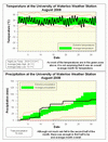
August 2008 Summary
An average month all around
The August daytime highs were about half a degree below average while the early morning lows were about half a degree above average. Not surprisingly this means the month was average overall with only a few days that were more than 5 degrees off of the average. We certainly haven't seen any extended hot weather streaks this year with only two days above 30°C so far in 2008 and they were both way back in early June.
After two very extreme months of precipitation, August was only average. The 79.2 mm was below the average of 87.0 mm, but still within the average range. However, 62 mm of that fell during the first half of the month leaving the second half dare I say dry? I don't want to say we are in a drought, but it was the driest 15 day period since late May - early June.
We have had 746.7 mm of precipitation so far in 2008 compared to the average for this time of year of 596.0 mm. This is the second highest total at this point of the year since 1970. We are chasing 1985 which had 803.8 mm at the end of August and did end up having the recent record for wettest year. Going back to the 1915, where missing data periods becomes an issue, there are 4 more years with higher values as of August 31st. So we can say that so far it is the 6th wettest year since record keeping began back in 1915.
Environment Canada prediction of temperature for the month: Average
Actual Temperature: Average
Summary for August 2008:
Maximum Temperature 28.6 °C
Minimum Temperature 6.9 °C
Average Daily High Temperature 24.1 °C (Long term average 24.8 °C)
Average Daily Low Temperature 13.1 °C (Long term average 12.7 °C)
Total Precipitation 79.2 mm (Long term average 87.0 mm)
(Long term averages based on 1970-2000 data for the Waterloo Wellington Airport)
Follow this link to see the graph showing the temperature and precipitation:
Sign up to get the monthly weather station summary by e-mail
Subscribe to:
Posts (Atom)


