Well no doubt about that one.
We got 2 cm last night to make October 29th the first official day with measurable snow at the UW weather station for the 2008-09 snowfall season.
Only 256 cm more and we break the all time record!
Wednesday, October 29, 2008
Friday, October 24, 2008
Perhaps the first snow of the season?
With snow in the forecast I always get the question about how to tell when we get the first snow of the season at the UW weather station.
This question (along with many other) are answered on the Frequently Asked Questions(FAQ) page.
Here were the first occurrences of measurable snow on the ground for the past few years:
2001 - Nov 20
2002 - Nov 2
2003 - Nov 29
2004 - Nov 7
2005 - Nov 17
2006 - Oct 13
2007 - Nov 16
This question (along with many other) are answered on the Frequently Asked Questions(FAQ) page.
Here were the first occurrences of measurable snow on the ground for the past few years:
2001 - Nov 20
2002 - Nov 2
2003 - Nov 29
2004 - Nov 7
2005 - Nov 17
2006 - Oct 13
2007 - Nov 16
Tuesday, October 21, 2008
The return of windchill
Although the official high temperature for Tuesday, October 21st was 8.2°C, that happened at midnight.
So the "daytime" high was only around 4°C, which makes it a very cold day.
It was also the first time I can remember seeing the Windchill graph appear on the Weather Graphs page since the spring.
But we didn't see any of the snow that was predicted by some of the long range forecasts from last week.
OK maybe some of the precipitation I saw today looked kind of solid, but I didn't see anything that could be actually be classified as snow.
Friday, October 17, 2008
Fall Colours
Looks like it will be a fine weekend to enjoy the fall colours.
Here are some sites that give you the current status of the trees around Ontario:
Ontario Parks
Ministry of Tourism
Here are some sites that give you the current status of the trees around Ontario:
Ontario Parks
Ministry of Tourism
Friday, October 10, 2008
Thanksgiving weekend 2008
Pre-weekend post:
It doesn't look like this Thanksgiving weekend is going to be as nice as last year's when the average temperature was around 27°C and we got to 30°C on the Monday.
However, if we get to the mid-twenties it will still be 10 degrees warmer than the average for this time of year and there is no rain in the forecast, so that's not too bad.
After-weekend post:
I don't think there can be any complaints about the Thanksgiving weekend, the average temperature was around 24°C and no rain to be seen.
Tuesday, October 7, 2008
First Frost Day
At 5:00 am on the morning of Tuesday, October 7th the temperature when below zero for the first time since the spring, making it the first frost day of the fall.
The last time we had a frost day was back on May 1st. This made for 158 frost free days during the summer, which is exactly the average over the last 10 years.
The last time we had a frost day was back on May 1st. This made for 158 frost free days during the summer, which is exactly the average over the last 10 years.
Monday, October 6, 2008
Possible first frost day
There is a forecast low of -1°C for Monday night/Tuesday morning.
This would be the first frost of the season.
In the 10 years of the UW weather station the first frost day has ranged between October 2nd and October 28th, with the average coming in around the 11th.
But no matter if it does actually go below zero at the station, depending on your particular location there is a good chance that you will get frost and you should make appropriate arrangements for your delicate plants.
Cold Day
On Thursday, October 2nd the high only reached 10.3°C.
This is the coldest daytime high temperature since May 21st.
This is the coldest daytime high temperature since May 21st.
Wednesday, October 1, 2008
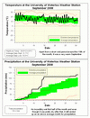
September 2008 Summary
A hot month with above average precipitation
In the 10 year history of the UW weather station, the temperature in September has been the most above the average of any month and this year is no different. In total, 8 of the last 11 Septembers have been above average and the other 3 have been average with none below average (looking back the Environment Canada archive, 1993 was the last time we had a cold September). This year it was 1.6 degrees warmer than the standard average period of 1971-2000.
We were on a torrid pace during the first half of the month with 107.6 mm of precipitation by the 15th, however since then we have only had another 8.6 mm. This still puts us far above the average of 87.5 mm, but if we had doubled the first half total it would have been something to see.
With 862.9 mm of precipitation at the end of September, this is now the 5th wettest first 9 months of the year since record keeping began back in 1915.
Environment Canada prediction of temperature for the month: Average
Actual Temperature: Above average
Summary for September 2008:
Maximum Temperature 29.9 °C
Minimum Temperature 4.8 °C
Average Daily High Temperature 21.7 °C (Long term average 20.2 °C)
Average Daily Low Temperature 10.3 °C (Long term average 8.5 °C)
Total Precipitation 116.2 mm (Long term average 87.5 mm)
(Long term averages based on 1971-2000 data for the Waterloo Wellington Airport)Follow this link to see the graph showing the temperature and precipitation:
Sign up to get the monthly weather station summary by e-mail
Subscribe to:
Posts (Atom)


