The UW weather station got a mention in Environment Canada's regional weather highlights for 2008.
We are mentioned under the "Soaker Storms in Kitchener-Waterloo" story.
Canada's Top Ten Weather Stories for 2008 - Regional Weather Highlights 2008
Tuesday, December 30, 2008
Could be the wettest December ever!
Another record we are going for in these last days of 2008:
The highest ever December precipitation was 1949 with 139.7 mm.
As of 9:30 am on Monday, December 29 we have had 132.5 mm.
We are expected to get about 5 cm of snow on Tuesday night, as that usually translates into about 5 mm of precipitation we will probably be very close to the record.
The highest ever December precipitation was 1949 with 139.7 mm.
As of 9:30 am on Monday, December 29 we have had 132.5 mm.
We are expected to get about 5 cm of snow on Tuesday night, as that usually translates into about 5 mm of precipitation we will probably be very close to the record.
Saturday, December 27, 2008
Annual precipitation total
A few weeks back I said that it would be very hard for us to move up from third spot on the list of the highest annual precipitation totals in the area.
But then we got all this rain.
The current highest precipitation we have had in the area was 1186.4 mm in 1985 and the second highest was 1174.9 mm in 1940.
As of 4:00 pm on Saturday, December 27 we have had 1152.2 mm in 2008.
But then we got all this rain.
The current highest precipitation we have had in the area was 1186.4 mm in 1985 and the second highest was 1174.9 mm in 1940.
As of 4:00 pm on Saturday, December 27 we have had 1152.2 mm in 2008.
Monday, December 22, 2008
Fall 2008 Summary
The snowiest fall since 1951 (3rd snowiest ever) with below average temperatures
(Long term averages based on 1971-2000 data for the Waterloo Wellington Airport)
Follow this link to see the graph showing the temperature and precipitation:
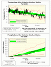
With 96 cm of snow, the fall of 2008 ranks as the third snowiest fall since records in the area began back in 1915 (the two snowiest were 1950 with 114.5 cm and 1951 with 105.5 cm). However what we got as snow we didn't get as rain, so the total precipitation of 250.4 mm puts it just barely above the average range.
Looking at the temperature, there were a couple of warmer than average periods during late September and early October. But after reaching 20 °C in early November the temperature was consistently lower than average for the rest of the season. Even though overall it was only 0.7 °C colder than the average, it still ranks as the coldest fall in the 10 year history of the UW weather station.
Summary for Fall 2008:
Maximum Temperature 26.2 °C
Minimum Temperature -18.8 °C
Average Daily High Temperature 7.9 °C (Long term average 8.5 °C)
Average Daily Low Temperature -1.1 °C (Long term average -0.3 °C)
Total Precipitation 250.4 mm (Long term average 222.5 mm)
(Long term averages based on 1971-2000 data for the Waterloo Wellington Airport)
Follow this link to see the graph showing the temperature and precipitation:
Sign up to get the monthly weather station summary by e-mail
Friday, December 19, 2008
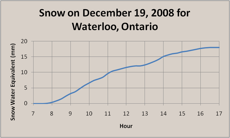
Snow-maggeddon - December 19th version
Unofficial "snow-maggeddon" totals for December 19th.
7:00 am - 0.0 cm
8:00 am - 0.5 cm
9:00 am - 2.0 cm
10:00 am - 5.5 cm
11:00 am - 10.0 cm
12:00 pm - 11.5 cm
1:00 pm - 13.0 cm
2:00 pm - 15.0 cm
3:00 pm - 16.5 cm
4:00 pm - 18.0 cm
5:00 pm - 18.5 cm
This will be final update as the snow stopped around 5 pm.
Here is graph showing the intensity of the storm.
As you can see from the graph the storm had a very consistent intensity for most of the day, with a bit of break around 1 pm.
Listen to my chat about today's storm with Carlos and Gayle from DaveFM.
Download the chat here.
Wednesday, December 17, 2008
Very snowy fall
Depending on how much of the forecasted snow we get this Friday, this fall could make it into the top three snowiest fall seasons since record keeping began back in 1915.
As of Wednesday morning we have had 75.5 cm of snow this fall.
Right now the top three are:
1950 - 114.5 cm
1951 - 105.5 cm
1921 - 81.0 cm
As of Wednesday morning we have had 75.5 cm of snow this fall.
Right now the top three are:
1950 - 114.5 cm
1951 - 105.5 cm
1921 - 81.0 cm
Monday, December 15, 2008
Cold temperatures are a coming.
With a cold front coming across southern Ontario today, I thought it might be interesting to watch the contrast in temperatures across the region as the day progresses.
As of 9:30 am:
Flint -2°C
Sarnia 5°C
London 8°C
Waterloo 7°C
Burlington 10°C
Toronto 10°C
St. Catharines 13°C
As of 10:30 am:
Flint -3°C
Sarnia 4°C
London 8°C
Waterloo 7°C
Burlington 11°C
Toronto 11°C
St. Catharines 11°C
As of 11:30 am:
Flint -5°C
Sarnia 1°C
London 7°C
Waterloo 5°C
Burlington 10°C
Toronto 9°C
St. Catharines 11°C
As of 12:30 am:
Flint -6°C
Sarnia -1°C
London 5°C
Waterloo 2°C
Burlington 8°C
Toronto 8°C
St. Catharines 10°C
As of 1:30 pm:
Flint -7°C
Sarnia -2°C
London 2°C
Waterloo 0°C
Burlington 7°C
Toronto 7°C
St. Catharines 8°C
As of 2:30 pm:
Flint -8°C
Sarnia -3°C
London 1°C
Waterloo -2°C
Burlington 5°C
Toronto 3°C
St. Catharines 6°C
As of 3:30 pm:
Flint -8°C
Sarnia -4°C
London -1°C
Waterloo -3°C
Burlington 3°C
Toronto 1°C
St. Catharines 5°C
As of 4:30 pm:
Flint -8°C
Sarnia -5°C
London -2°C
Waterloo -5°C
Burlington 2°C
Toronto -1°C
St. Catharines 4°C
As of 5:30 pm:
Flint -8°C
Sarnia -6°C
London -4°C
Waterloo -6°C
Burlington 0°C
Toronto -1°C
St. Catharines 2°C
Friday, December 12, 2008
December 12th snowfall update
I'm going to try and put out a snowfall update for the season each week.
As of December 12th:
2008-09 season - 69 cm
2007-08 season - 30 cm
Long term average - 35 cm
Still more than twice last year's amount and the official start to winter is over a week away.
As of December 12th:
2008-09 season - 69 cm
2007-08 season - 30 cm
Long term average - 35 cm
Still more than twice last year's amount and the official start to winter is over a week away.
Wednesday, December 10, 2008
Third wettest year of all time
With the mixed bag of precipitation we saw on December 9th, the total precipitation for this year passed the 1064.6 mm recorded during 1986.
That means 2008 is now officially the third wettest year for this region since records began back in 1915.
But it will be a challenge to move up any higher as the second spot is currently held by 1940 with 1174.9 mm and the wettest year was in 1985 when 1186.4 mm was recorded.
As we would need another 100 mm in the three remaining weeks of the year to get to the top, we will probably have to happy with third place.
Friday, December 5, 2008
December 5th snowfall update
It seems that people are interested in how this snow season is comparing to last year's record setting one.
Well last year on December 5th our snowfall total was 27.5 cm, while this year we have already had 52 cm.
That is almost twice as much as last year, but we still have a long way to go to beat last year's record of 257.5 cm.
Well last year on December 5th our snowfall total was 27.5 cm, while this year we have already had 52 cm.
That is almost twice as much as last year, but we still have a long way to go to beat last year's record of 257.5 cm.
Monday, December 1, 2008
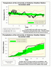
November 2008 Summary
Another wet month with cold temperatures
It isn’t very hard to see when the weather changed this November, after a few days that were close to 20 °C in the first week and a high of 8 °C on the 15th, the temperature went south and never again got above 2.5 °C. The contrast between the two halves of the month can clearly be seen in the temperature graph (see the link below); as well you can see the period near the end of the month when the temperature hovered around 0 for almost 4 days.
Overall the month was 0.8 degrees below average, this is a bit warmer than last year’s November when it was 0.9 degrees below average. However, the daily highs were actually colder this year than they were last year, but the daily lows were warmer making the overall average temperature a bit warmer.
Another month of above average precipitation with 115.0 mm coming down compared to the average of 82.3 mm. Most of this occurred between the 14th and 16th (48.8 mm), during the transition between the warm and cold parts of the month.
A total of 1023.2 mm of precipitation has been recorded so far this year, which is of course well above the average of 835.6 mm. We have now had the 3rd highest precipitation for the first 11 months of any year since records in the area began back in 1915.
It will however be difficult to end up with the wettest year on record, to do this we would need 163 mm in December to overtake 1985 and 151 mm to come in second just ahead of 1940. To put this into perspective the highest total precipitation for the month of December was 139.7 mm in 1949.
Summary for November 2008:
Maximum Temperature 20.4 °C
Minimum Temperature -12.8 °C
Average Daily High Temperature 5.2 °C (Long term average 6.1 °C)
Average Daily Low Temperature -2.0 °C (Long term average -1.4 °C)
Total Precipitation 115.0 mm (Long term average 82.3 mm)
(Long term averages based on 1971-2000 data for the Waterloo Wellington Airport)
Follow this link to see the graph showing the temperature and precipitation:
Sign up to get the monthly weather station summary by e-mail
Subscribe to:
Posts (Atom)


