Forecasted lows of 1°C for Sunday morning, I thought we were over this madness.
Sunday morning update: the low was 3.4°C
Saturday, May 30, 2009
Thursday, May 28, 2009
A couple of very wet days
On Wednesday, May 27th there was 25.4 mm (exactly an inch) of rain followed by 19.8 mm on Thursday, May 28th.
Tuesday, May 19, 2009
Cold mornings during the Victoria Day long weekend
As forecasted, it did go below zero on the Monday morning of the long weekend.
The temperature got down to -0.3°C making it a cold morning for those camping during the long weekend.
Please leave your experiences with the weather this weekend as comments on the blog page.
The temperature got down to -0.3°C making it a cold morning for those camping during the long weekend.
Please leave your experiences with the weather this weekend as comments on the blog page.
Friday, May 15, 2009
Another cold Victoria Day weekend
The forecast has been jumping around a bit, but right now there is a forecast high of only 6°C on Sunday and of course a low of -2°C for Monday morning.
Another chilly Victoria Day long weekend.
Another chilly Victoria Day long weekend.
Tuesday, May 12, 2009
Two days in a row!
After falling to -0.6°C Monday morning, the temperature went below zero (down to -0.8°C) again on Tuesday morning.
That could be end of it however, as there is no frost predicted in the current 7 day forecasts.
That could be end of it however, as there is no frost predicted in the current 7 day forecasts.
Monday, May 11, 2009
It happened this morning and it might happen again
The forecasts were correct, the temperature dipped down to -0.6 °C this morning.
And it looks like another cold night tonight that might again lead to below zero temperatures.
And it looks like another cold night tonight that might again lead to below zero temperatures.
Sunday, May 10, 2009
Hope you didn't plant those annuals
A frost warning has been issued for Sunday night/Monday morning, take heed anybody who jumped the gun and maybe put out some plants that they shouldn't have.
If it happens, this would make it the first time since mid-April that the temperature would get below zero.
The old standard of waiting to start a garden till the Victoria Day weekend still seems to be words to live by.
If it happens, this would make it the first time since mid-April that the temperature would get below zero.
The old standard of waiting to start a garden till the Victoria Day weekend still seems to be words to live by.
Wednesday, May 6, 2009
UW Weather station MAC OS application II
So I ask for weather station apps, I get some and then I take a really long time to distribute them, not a good way to encourage future development.
To correct this, here is another application for the Mac OS X operating system, this one sent in by Jeffrey Ouimen. As I don't have the means to test out the application, but I encourage anybody who does to please leave feedback on the blog.
Note that the UW weather station is not responsible for the content or the operation of this application.
Contact information for Jeffrey can be found on his website (link below).
You can either download the zip file containing the latest version of the application here:
UW_Weather_Dashboard Widget
Current version is 1.0, available May 5, 2009
or you can download it from Jeffrey's website.
Friday, May 1, 2009
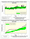
April 2009 Summary
A very wet month with average temperature
Just like March the temperature was about 0.8 degrees above average in April, but again it wasn't quite hot enough to call it an above average month. Even with two days over 25 °C and only a couple of really cold days, the overall temperature was still within the average range.
Also interesting is that the last day the temperature was below zero was back on April 17th, now I'm not suggesting that you can start to plan your annuals, but if we don't see frost again this year it would be the earliest last frost in at least the last 10 years (if we don't see zero in May I'll look it up historically).
And in UW weather station news, the temperature went over 20 °C at 1:30 on April 18th, making Ross Schneider the winner of this year's weather station contest, with Michael Theunissen coming in second.
The 128.6 mm of precipitation we saw during the month made it the wettest April since 1996 and the 5th wettest of all time since records began in the area back in 1914. Almost all of the precipitation came during 5 days of the month: 29.4 mm on the 3rd, 15.7 mm on the 6th, 18.0 mm on the 20th, 18.8 mm on the 25th, and 25.0 mm on the 30th. The 10.5 cm of snow for the month was a little bit more than the 7.8 cm we get on average.
We are again having a wet year with 326.4 mm of precipitation so far compared to the average of 262.2 mm.
Although historically we have had snow in May, I'm going to call an end to the 2008-09 snowfall season. The snowfall season ended with a whimper, with very little snow after the end of January, but if you remember back to last fall and the early winter we thought the snow would never end. The total snowfall was 235.0 cm which is tied for the third highest total of all time with 1942-1943 and behind both the 245.3 cm in 1923-24 and the 257.5 cm last year.
Environment Canada prediction of temperature for the month: Above average
Actual Temperature: Average
Summary for April 2009:
Maximum Temperature 26.1 °C
Minimum Temperature -5.4 °C
Average Daily High Temperature 12.1 °C (Long term average 11.4 °C)
Average Daily Low Temperature 1.5 °C (Long term average 0.6 °C)
Total Precipitation 128.6 mm (Long term average 76.9 mm)
(Long term averages based on 1971-2000 data for the Waterloo Wellington Airport)
Sign up to get the monthly weather station summary by e-mail
Subscribe to:
Posts (Atom)


