So far for 2009:
The warmest day was 31.3°C on June 24th.
The coldest day was -28.8°C on January 15th.
Largest one day temperature range was 20.4° on February 7th.
Smallest one day temperature range was 2.4° on February 11th.
The wettest day was 29.4 mm on April 3rd.
Monday, July 27, 2009
Friday, July 17, 2009
Canada=cold, rest of world=hot
I found this interesting in the latest global climate monitoring report:
The January-June year-to-date tied with 2004 as the fifth warmest on record. The January-June 2009 map of temperature anomalies shows the presence of warmer-than-average conditions across much of the world's land areas, with the exception of cooler-than-average temperatures across Canada.

So apparantly it is only Canada that has been colder than average so far this year, although the dot closest to us in Waterloo is actually red indicating slightly above average temperatures.
The January-June year-to-date tied with 2004 as the fifth warmest on record. The January-June 2009 map of temperature anomalies shows the presence of warmer-than-average conditions across much of the world's land areas, with the exception of cooler-than-average temperatures across Canada.
So apparantly it is only Canada that has been colder than average so far this year, although the dot closest to us in Waterloo is actually red indicating slightly above average temperatures.
Wednesday, July 15, 2009
Coldest first 15 days of July in history
The average daily high temperature for the first 15 days of July 2009 have only averaged 21.9°C. This is lower than any previous start of July since records began in the region in 1915**.
The previous coldest was 1917 when the daily highs averaged 22.4°C .
The average daily low temperature has been 11.2°C and for that only the year 1950 had a lower average (10.8°C), but overall this year has been colder than 1950.
As I've been saying you have to go to Whitehorse to find the summer, their high temperatures in July so far have actually been higher than ours (24.0°C). But their low temperatures make their overall average a bit lower than ours. As well, they had a temperature of -1.2°C on June 28th, that's kind of nasty.
** Records for the region started in October of 1914, so for July we have records back to 1915, the July data is also missing for 1939 but there is nothing to indicate from nearby records that it was a unusually cold
Saturday, July 11, 2009
Quite a shot of rain!
Between 8:45 and 9:00 am Saturday morning we got 15.4 mm of rain.
That is the third highest 15 minute rainfall in the last 10 years, the two higher ones were the 15.9 mm on May 12, 2000 and 23.0 mm last July 22nd.
That is the third highest 15 minute rainfall in the last 10 years, the two higher ones were the 15.9 mm on May 12, 2000 and 23.0 mm last July 22nd.
Friday, July 10, 2009
Everyone wants to know Where is the summer?
First off on Thursday I was on CBC's Ontario Morning with Wei Chen:
Follow this link to listen to the conversation
Then on Friday morning I was talking with Carlos and Gayle of DAVE-FM:
Follow this link to listen to the conversation.
OK I re-used the villagers with pitchforks and torches line, but I thought it was a good one.
Follow this link to listen to the conversation
Then on Friday morning I was talking with Carlos and Gayle of DAVE-FM:
Follow this link to listen to the conversation.
OK I re-used the villagers with pitchforks and torches line, but I thought it was a good one.
Wednesday, July 8, 2009
Yes that was a cold day for July
The high temperature on Tuesday, July 7th only got up to 15.9°C.
That made it the lowest daytime high temperature since 1997 and the fifth lowest since 1971.
Here is a list of the only July days that we didn't beat:
14.2°C July 8th, 1995
14.3°C July 31th, 1992
14.6°C July 4th, 1997
15.6°C July 7th, 1984
That made it the lowest daytime high temperature since 1997 and the fifth lowest since 1971.
Here is a list of the only July days that we didn't beat:
14.2°C July 8th, 1995
14.3°C July 31th, 1992
14.6°C July 4th, 1997
15.6°C July 7th, 1984
Wednesday, July 1, 2009
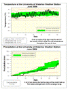
June 2009 Summary
A cold June with average precipitation
Even a streak of very hot days near the end couldn't prevent the month from being the coldest June since 2004. Overall, the daytime high temperatures were 1.5 degrees below average including 5 days that were colder than average by more than 5 degrees. It also got down to a frigid 2.9 °C on the morning of the 4th, this was the coldest June temperature since 1998.
A wet end to the month brought us back into the average range for precipitation after a dry start, the final total was 75.8 mm which isn’t too far below the average of 80.0 mm.
The total for the year so far is 485.2 mm compared to an average of 415.0 mm. Although we have had a lot of precipitation this year, it still only ranks as the 6th wettest year going back to 1971, so unless we kick up the pace it doesn't look like it will be an extreme year.
Environment Canada prediction of temperature for the month: Below average
Actual Temperature: Below average
Summary for June 2009:
Maximum Temperature 31.3 °C
Minimum Temperature 2.9 °C
Average Daily High Temperature 22.1 °C (Long term average 23.6 °C)
Average Daily Low Temperature 11.3 °C (Long term average 11.3 °C)
Total Precipitation 75.8 mm (Long term average 80.0 mm)
(Long term averages based on 1971-2000 data for the Waterloo Wellington Airport)
Sign up to get the monthly weather station summary by e-mail
Subscribe to:
Posts (Atom)


