Monday, August 17, 2009
Warmest night in three years
The temperature only got down to 21.8°C on Sunday night / Monday morning, that was the warmest night since way back on August 1st, 2006 when it only went down to 25.3°C.
Wednesday, August 12, 2009
Summer weather this week
Like it, love it, or hate it, this week looks to have more typical summer weather, sunny days with highs in the upper 20s.
Monday, August 10, 2009
A good light show
Well the forecasts certainly delivered with respect to both the temperature and the humidity.
The temperature of 29.7°C combined with humidity that caused a humidex in the 40s combined with the unstable air to bring a couple of good light shows on Sunday.
The temperature of 29.7°C combined with humidity that caused a humidex in the 40s combined with the unstable air to bring a couple of good light shows on Sunday.
Thursday, August 6, 2009
Summer weather this weekend
For those of you that have been craving the sticky/summer weather (and for those that despise it you should also take notice) that the forecasts for Sunday are in the high 20s or low 30s depending on the forecast.
It also looks like we might get more than a couple days that are above average. The last time we had more than two days like that was back in late June.
It also looks like we might get more than a couple days that are above average. The last time we had more than two days like that was back in late June.
Saturday, August 1, 2009
July 2009 Summary
An historically cold July with average precipitation
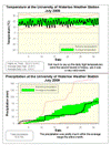
Wow, that was July? Really? Well yes it was and it was the second coldest July since records in the area began in 1915. That is when you consider the daily high temperatureswhere only July of 1992 was slightly colder (this year's average high temperatures were 22.6°C while it was only 22.2°C in 1992, compared to the average of 26.0°C). We only had 2 days this month where the high temperature was above average, so that makes 29 below average days.
The daily low temperatures came in at only 1.0 degrees below average which doesn't even rank in the top 10 (or bottom 10 depending on how you look at it) when looking at data since 1915.
By the way, lots of people said it felt like May or September, just want to go on record that even this cold July was warmer than an average May or September.
As I pointed out in my blog entry this month (see link below), the temperatures we have seen so far this year in Canada are unique in that it has been above average almost everywhere else in the world. In fact, the daily high temperatures for July in Whitehorse (and yes I know that's in Canada but it is a good example) were higher the ours, while in Texas they just recorded the hottest 30 days in their history, ever.
We had 17 days with some measured precipitation, which is a lot more than the average
of 10 days for July, this probably made it feel wetter than it actually was. As the total of 82.6 mm was still below the average of 92.9 mm, but close enough to be within the average range. There were only 2 days with over 10 mm of precipitation. While the total precipitation for the year so far is 567.8 mm compared to an average of 506.0 mm.
Usually I don't talk about the incoming solar radiation (a measure of how much of the sun's energy is getting to the surface), but a lot of people were saying that they never saw the sun this month. The only record we have of this is our own record at the UW weather station, so based on 10 years of data we were below the average, but back in 2004 there was even less incoming solar radiation so it wasn't historically low.
Summary for July 2009:
Maximum Temperature 26.0 °C
Minimum Temperature 8.4 °C
Average Daily High Temperature 22.6 °C (Long term average 26.0 °C)
Average Daily Low Temperature 12.6 °C (Long term average 13.8 °C)
Total Precipitation 82.6 mm (Long term average 92.9 mm)
(Long term averages based on 1971-2000 data for the Waterloo Wellington Airport)
Sign up to get the monthly weather station summary by e-mail
Subscribe to:
Posts (Atom)


