Friday, November 27, 2009
Next week's picture a bit clearer
Gotta give this one to Environment Canada as The Weather Network forecast has now dropped to within a few degrees of the Environment Canada predictions for Monday and Tuesday.
Wednesday, November 25, 2009
What's going to happen early next week?
An interesting split in the forecasts for next Monday and Tuesday.
As of 4 pm on Wednesday afternoon Environment Canada is predicting a high of 2°C and a low of 0°C for Monday with flurries or rain. For Tuesday they call for 30% chance of flurries with the high temperature of only 1°C and a low temperature of -2°C.
Now we look over to the Weather Network and they have highs of 5°C and 8°C with lows of 2°C and 1°C for Monday and Tuesday with all the precipitation coming down as rain.
So for both days the range of temperatures in the forecasts don't even overlap, I guess we will find out next week who was correct (or maybe it will end up somewhere in the middle as it often does).
Wednesday, November 18, 2009
Weather chat on Dave-FM
Follow this link to listen to me and Carlos from Dave-FM talking about the warm start to November.
http://www.davefm.com/home/FunStuff/CarlosBenevidesBlog/tabid/831/id/23746/Default.aspx
Monday, November 16, 2009
A warm and dry November so far
With the first 15 days of November in the books it has been quite a turn around since October. So far we are over 3 degrees above average, with 3 days more than 10 degrees warmer than we would expect at this time.
Also, where has the precipitation gone? Only 7.2 mm so far, going to be tough to get to the average of 82.3 mm for the month.
Also, where has the precipitation gone? Only 7.2 mm so far, going to be tough to get to the average of 82.3 mm for the month.
Sunday, November 8, 2009
A November day hotter than any one in October
The high temperature on the 8th got up to 18 degrees which was hotter than any day we saw in October and was the warmest day since September 27th.
Also as pointed out in the comments on the October summary by Rob Kuhn: the temperature didn't go above 20 degrees in all of October, which hasn't happened since 1987.
And in fact the 17.2 degree extreme high temperature this October was almost the record lowest since records began in the area over 90 years ago. We ended up tying 1925 when 17.2 was also the warmest temperature seen in October, but in every other year there was at least a single day that was warmer. My apologies for not recognizing this and putting it in the summary.
Sunday, November 1, 2009
October 2009 Summary
October was wet with cold days and warm nights
Just looking at the overall average temperature for the month it was about half a degree below average, this is still within the average range so it was officially an average month for temperature.
However, digging a bit deeper into the numbers, it was another month where there was a large difference between the daily high and low temperatures. The daily high temperatures were 1.5 degrees below average while the daily low temperatures were actually 0.4 degrees above average. As I have pointed out in the past, I’m of the belief that most people are more aware of the high temperature of the day and thus would have perceived October as a very cold month.
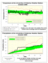
Looking at the graph of the temperature, you can really see the week between the 11th and the 17th where it was more than 5 degrees below average and how the temperature rebounded in the last half of the month. The first frost of the year happened on the evening of the 11th, a little later than the average date which is the first of the month.
During the first 10 or so days of the month it looked like we might be on track for a record wet October, but then almost 2 weeks of dry weather put in an end to that. A few storms in the last week put the total precipitation for the month at 84.4 mm, more than enough greater than the average of 67.1 mm to classify it as above average.
With the total precipitation for the year (784.7 mm) still close to the average (748.3 mm), it will take some pretty extraordinary numbers in these last couple of months of the year to get us out of the average range.
Summary for October 2009:
Maximum Temperature 17.2 °C
Minimum Temperature -4.7 °C
Average Daily High Temperature 11.7 °C (Long term average 13.2 °C)
Average Daily Low Temperature 3.2 °C (Long term average 2.9 °C)
Total Precipitation 84.4 mm (Long term average 67.1 mm)
(Long term averages based on 1971-2000 data for the Waterloo Wellington Airport)
Just looking at the overall average temperature for the month it was about half a degree below average, this is still within the average range so it was officially an average month for temperature.
However, digging a bit deeper into the numbers, it was another month where there was a large difference between the daily high and low temperatures. The daily high temperatures were 1.5 degrees below average while the daily low temperatures were actually 0.4 degrees above average. As I have pointed out in the past, I’m of the belief that most people are more aware of the high temperature of the day and thus would have perceived October as a very cold month.
Looking at the graph of the temperature, you can really see the week between the 11th and the 17th where it was more than 5 degrees below average and how the temperature rebounded in the last half of the month. The first frost of the year happened on the evening of the 11th, a little later than the average date which is the first of the month.
During the first 10 or so days of the month it looked like we might be on track for a record wet October, but then almost 2 weeks of dry weather put in an end to that. A few storms in the last week put the total precipitation for the month at 84.4 mm, more than enough greater than the average of 67.1 mm to classify it as above average.
With the total precipitation for the year (784.7 mm) still close to the average (748.3 mm), it will take some pretty extraordinary numbers in these last couple of months of the year to get us out of the average range.
Summary for October 2009:
Maximum Temperature 17.2 °C
Minimum Temperature -4.7 °C
Average Daily High Temperature 11.7 °C (Long term average 13.2 °C)
Average Daily Low Temperature 3.2 °C (Long term average 2.9 °C)
Total Precipitation 84.4 mm (Long term average 67.1 mm)
(Long term averages based on 1971-2000 data for the Waterloo Wellington Airport)
Sign up to get the monthly weather station summary by e-mail
Subscribe to:
Posts (Atom)


