Thursday, February 25, 2010
Better late than never
The entry period for the 2010 edition of the UW weather station contest has started.
See all the details and enter the contest here.
The entry period ends at 3 pm on Thursday March 4th, so get those guesses in.
Monday, February 15, 2010
Very average temperatures and a dry start to the month
The last time we had a daily high temperature that was more than 5 degrees off the average (either above or below) was back on January 29th.
Since then we have seen relatively steady daily high temperatures.
By the way, this doesn't hold true for the daily low temperature where it has been both 5 degrees above and below the average a few times since the beginning of February.
For the first half of February there has only been 5.5 mm of precipitation, the record low for the month is 10.8 mm.
Monday, February 8, 2010
Not a lot of snow so far
Although it looks like we are going to get some more this week, so far this snowfall season we have 0nly had 52 cm of snow. This is only half of the average of around 100 cm at this time of year and a quarter of where we were last year.
Here is the graph showing the snowfall story:
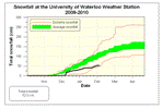 Note that the extreme snowfall amounts are based on the measurements at the UW weather station so they only go back to the 2001-2002 snowfall season, while the average range is based on measurements from the Waterloo-Wellington airport from 1971-2000.
Here is the graph showing the snowfall story:
Note that the extreme snowfall amounts are based on the measurements at the UW weather station so they only go back to the 2001-2002 snowfall season, while the average range is based on measurements from the Waterloo-Wellington airport from 1971-2000.
Monday, February 1, 2010
January 2010 summary
The driest January in 30 years while temperatures were about average
The driest January in 30 years while temperatures were about average
A very cold start to the month was balanced by a warm second half (except for the last few days) to make for an overall average month for temperature. During that second half we had a stretch of 14 warmer than average days.
The daily highs came in at 0.2 degrees below average and the daily low temperatures were 1.3 degrees above average. So overall it was 0.5 degrees above average which is still within the average range.
But the big story for January was the lack of precipitation both solid and liquid. The total precipitation was only 27.9 mm, making it the driest January since 1981 and tied for the fourth driest since records began in the area in 1914.
As far as snow, we only saw 17.5 cm. This is the least snowiest January since 1983, the seventh lowest total January snowfall in history, and less than half the average of 44 cm.
It is understandable that people have been commenting on the lack of shovelling they have had to do this winter, as we have only had 47 cm so far this snowfall season compared to the average of 97 cm. It is also quite a contrast to last year when we had around 200 cm at this point.
Summary for January 2010:
Maximum Temperature 5.2°C
Minimum Temperature -21.5°C
Average Daily High Temperature -3.3°C (Long term average -3.1°C)
Average Daily Low Temperature -9.8°C (Long term average -11.1°C)
Total Precipitation 27.9 mm (Long term average 64.4 mm)
(Long term averages based on 1971-2000 data for the Waterloo Wellington Airport)
Sign up to get the monthly weather station summary by e-mail
Subscribe to:
Posts (Atom)


