As of Monday evening, The Weather Network is forecasting a high of 28°C for Friday with a Humidex of 34. If that were to come to pass it would be the highest temperature seen in April since 1990. Keep in mind that is for the entire month of April, I'll have to dig deeper into the data to see how it ranks for the first half of April.
But Friday is still a while away, so we will see if that forecast holds up for the next couple of days.
Monday, March 29, 2010
Wednesday or Thursday?
It looks like the weather station contest will definitely come to an end this week. Right now Environment Canada is calling for a high of 19 on Wednesday and 23 on Thursday, looks like it has to happen on one of those days.
Friday, March 26, 2010
Cold this be the coldest day for the next 6 months?
Whatever the high turns out to be on Friday, it looks like it might be the coldest daytime high for a while. The short and medium range forecasts all point to major warming this week and then staying near average after that.
Assuming we make it through the start of April without a colder day, it is likely we won't see another one this cold till September or even October.
Assuming we make it through the start of April without a colder day, it is likely we won't see another one this cold till September or even October.
Saturday, March 20, 2010
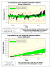
Winter 2009/2010 Summary
A warm winter with very little snow
Although the first months of the winter were only slightly warmer than average, the extremely warm temperatures of March made the entire season much hotter than average. Overall the temperature was 1.5 degrees higher than average, this makes it the warmest winter since 2005/2006 and the 3rd warmest of the last 10 years.
Also significant is that there weren't really any extended cold snaps. To put some numbers on it, we never had more than 2 days in a row when the temperature was more than 5 degrees below average. The last time we had a winter like that was back in the winter of 2001-2002.
But the real story of this past season was probably the lack of precipitation, in particular snow. We got 113.2 mm of precipitation (this is a combination of rain, snow, sleet, freezing rain, and whatever else nature threw at us) compared to an average of 184.5 mm, so that's about two thirds of the average.
Unfortunately when it comes to snow, considering only the amounts during the 3 months of winter doesn't really tell the entire story. For now, I'll just say that for the winter season we only had 54 cm of snow which is about half of the average and the lowest since the winter of 1981/82. The full story will come after the end of the snowfall season, which goes until there is no reasonable expectation of any more snow (probably sometime in April).
An unscientific poll done on the UW weather station blog revealed that although most people thought the winter was great (38%), there were still a good number (21%) that wanted a real winter. I had a feeling it would be a polarizing kind of winter that either you really liked or really hated.
Final poll tally: Great 87 (38%), Good 40 (17%), OK 34 (15%), Bad 17 (7%), Washout 48 (21%), total number of votes: 226.
Summary for Winter 2009/2010:
Maximum Temperature 16.9°C
Minimum Temperature -21.5°C
Average Daily High Temperature -0.3°C (Long term average -1.4°C)
Average Daily Low Temperature -8.0°C (Long term average -9.8°C)
Total Precipitation 113.2 mm (Long term average 184.5 mm)
(Long term averages based on 1971-2000 data for the Waterloo Wellington Airport)
Sign up to get the monthly weather station summary by e-mail
Thursday, March 11, 2010
Winter 2009/2010 poll
Spring officially starts next week so let's find out what everbody thought of the winter. The final numbers aren't in but obviously it was a warm and dry winter.
You can cast your vote on the UW weather station blog and just like the summer poll there are five categories (great, good, OK, bad, and washout).
I'm not really sure how this one is going to turn out.
You can cast your vote on the UW weather station blog and just like the summer poll there are five categories (great, good, OK, bad, and washout).
I'm not really sure how this one is going to turn out.
Monday, March 8, 2010
Warmest day in 3 months
The high temperature on Monday of 8.8°C was the highest temperature we have seen since December 2nd (9.2°C).
Monday, March 1, 2010
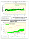
February 2010 Summary
Another dry month with average temperatures
Apart from a couple of colder nights in the first week of the month, the temperatures in February stayed very much within the average range. The daily high temperatures were never more than 5 degrees away from the average while the lows only occasionally got out of that range, mostly on the warm side. But even these warm nights couldn’t get the temperature out of the average range overall.
Another dry month with only 30.9 mm compared to the average of 51.3 mm. Almost half of that came during the 22nd when 13.2 mm of precipitation came down. That storm prevented it from being a historically dry month, but it was still below average.
The total snowfall of around 30 cm was pretty much exactly the long term average, but as most of it came during one storm and as we had not seen much so far this winter it sure did feel like a lot. However what we were missing in February was the rain component of precipitation which is usually around 25 mm.
With a dry first two months of the year, the total precipitation for 2010 of 58.8 mm is only about half of the 117.0 we would expect by this time of year.
Summary for February 2010:
Maximum Temperature 3.1°C
Minimum Temperature -19.1°C
Average Daily High Temperature -2.0°C (Long term average -1.9°C)
Average Daily Low Temperature -8.7°C (Long term average -10.5°C)
Total Precipitation 30.9 mm (Long term average 51.3 mm)
(Long term averages based on 1971-2000 data for the Waterloo Wellington Airport)
Sign up to get the monthly weather station summary by e-mail
Subscribe to:
Posts (Atom)


