Some progress today!
We got the new equipment installed, not all the instruments are working but
hopefully in the next day or two updated readings will start to appear.
But there is also the possibility that some strange readings might pop up so be prepared.
Thank you for your patience.
Wednesday, May 26, 2010
Monday, May 17, 2010
Station still down
The necessary repairs are taking longer than we had hoped.
It turns out the device that ran everything at the station is the part that died.
As that part was over 15 years old we have been forced to upgrade to the current model.
Unfortunately this involves a whole new set of programming, so basically it is like starting the station from scratch again.
We will hopefully be installing the new device this week (May 17-22).
We are very sorry for the delay in getting back to updated readings.
Monday, May 10, 2010
Typical last frost day
Assuming that the last frost day was either on Monday (10th) or will be on Tuesday (11th), it will be a little later than the average last frost day which is May 6th in the area.
However, there is a very large range for the last time the temperature goes below zero as we have seen dates anywhere between the 25th of April and the 21st of May.
However, there is a very large range for the last time the temperature goes below zero as we have seen dates anywhere between the 25th of April and the 21st of May.
Sunday, May 2, 2010
April 2010 Summary
Warmest April in 55 years and finally an average month for precipitation
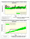
Just like March, it was another warm month, this one was 3.4 degrees above average, making it the warmest April since 1955 and tied for the forth warmest in the 90+ years of record keeping in the area. As well, the last time we had two consecutive months that were more than 3 degrees above average were the months of January and February of 2002.
We had 24 warmer than average days, 11 that were more than 5 degrees above average and only 3 days that were more than 5 degrees below average. I was also never able to find an April in the area when the lowest temperature was only -2.3 °C or put another way in every other April it always got colder than -2.3 °C.
For the first time this year we had an average month for precipitation with 67.6 mm coming down compared to an average of 76.9 mm. Of course 51.6 mm of this came during a 3 day period early in the month, so the rest of the month was dry.
It has been a dry start to the year with only about two thirds of the typical amount falling during the first four months of the year. In the past 45 years this is the second least amount of precipitation we have had at this point in the year (we had a little less in 2003).
I could have done this last month, but I think it is now safe to call an end to the 09/10 snowfall season. We only had 78 cm during the month which is less than half of the average amount (159.5 cm) and a lot less than what we saw during the two previous winters – 257.7 cm in 07/08 and 235 cm in 08/09.
Summary for April 2010:
Maximum Temperature 26.3 °C
Minimum Temperature -2.3 °C
Average Daily High Temperature 15.7 °C (Long term average 11.4 °C)
Average Daily Low Temperature 3.0 °C (Long term average 0.6 °C)
Total Precipitation 67.6 mm (Long term average 76.9 mm)
(Long term averages based on 1971-2000 data for the Waterloo Wellington Airport)
Sign up to get the monthly weather station summary by e-mail
Subscribe to:
Posts (Atom)


