In the annual UW Weather Station I had a hard time figuring out where the temperature ranked in the history of the region. The reason is that the records at the Waterloo-Wellington airport only go back to 1971 so to go back further we need to use a station in Kitchener that collected data from 1914 to 1977. Unfortunately between the stations there are going to be differences in equipment, personnel, and of course the location itself making comparison difficult.
When I did a straight ranking of annual temperatures from both stations the results looked like this:
1998 - 9.98
1949 - 8.64
1953 - 8.63
1931 - 8.63
1921 - 8.63
2006 - 8.44
1952 - 8.20
2001 - 8.14
1941 - 8.12
1955 - 8.07
1919 - 8.02
1975 - 7.96
1999 - 7.95
1991 - 7.88
2002 - 7.76
where the bolded number are from the Kitchener station. This would put the 2010 average
temperature of 7.90°C at 13th.
However as there are 7 years of overlap between the stations I was able to calculate that the Kitchener station was an average of 0.74 degree warmer than the Waterloo-Wellington airport station. This difference was very consistent for all 7 years.
So taking the Kitchener station numbers down by that amount make the ranking now look like this:
1998 - 9.98
2006 - 8.44
2001 - 8.14
1999 - 7.95
1949 - 7.90
1953 - 7.89
1931 - 7.89
1921 - 7.89
1991 - 7.88
2002 - 7.76
1952 - 7.46
1941 - 7.38
1955 - 7.33
1919 - 7.28
1975 - 7.22
So this puts 2010 as a tie for fifth overall.
To do a further check I looked for stations within 75 km of Waterloo that had long continuous records. Here are the four that I found:
Toronto airport (1938 - 2009) Missing 1939
1998 - 10.13
2006 - 9.70
2001 - 9.64
1999 - 9.46
2002 - 9.42
2005 - 9.02
2007 - 8.91
1991 - 8.88
1953 - 8.85
1949 - 8.73
London (1941-2001)
1998 - 9.88
2001 - 8.83
1953 - 8.83
1999 - 8.73
1987 - 8.73
1991 - 8.73
1949 - 8.68
1955 - 8.57
1990 - 8.47
Woodstock (1875-2006) Lots of missing years including 1953
1998 - 9.81
2001 - 8.97
1991 - 8.91
1990 - 8.69
1921 - 8.66
2006 - 8.65
1931 - 8.63
1999 - 8.55
2002 - 8.53
Fergus Shand Dam (1939-2006) Missing 1971
1998 - 8.74
2006 - 7.90
1999 - 7.79
2001 - 7.73
1991 - 7.55
2002 - 7.46
1990 - 7.43
1987 - 7.36
1949 - 7.25
2005 - 7.20
1953 - 7.10
Lots of numbers there, but what I was interested in seeing were not the absolute numbers, but the order of the years. It is pretty obvious that 1998 was by far the warmest in the region and the fact that at most of the stations, the same years that were in the top 5 in the Waterloo Region (1998, 2006, 2001, 1999, and 1991) were generally not only in the top at other stations but also higher than 1953 and 1949. All this increased my confidence that the order of the adjusted Waterloo Region data is reasonable.
This is the reasoning behind saying the 2010 was the 5th warmest year in the region since records began back in 1914.
Friday, December 31, 2010
Wednesday, December 22, 2010
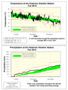
Fall 2010 Summary
A fall that saw both average temperature and precipitation
Up until the beginning of December it was looking to be a very warm fall. But since the start of the last month there have been only a few days that were above average. This brought the overall temperature for the fall down to half a degree above average, which is within the average range.
The precipitation was relatively well spread out over the season with the only prolonged dry spell occurring between late October and mid-November. The total precipitation was 228.7 mm which is a little higher than the average of 220.9 mm, but still within the average range.
For the second year in a row the total snowfall for the season of 30 cm was below the average of 40 cm and quite a bit lower than 2008 when we had 96 cm.
Summary for Fall 2010:
Maximum Temperature 27.6 °C
Minimum Temperature -17.4 °C
Average Daily High Temperature 8.8 °C (Long term average 8.3 °C)
Average Daily Low Temperature -0.1 °C (Long term average -0.5 °C)
Total Precipitation 228.7 mm (Long term average 220.9 mm)
(Long term averages based on 1970-2000 data for the Waterloo Wellington Airport)
Sign up to get the monthly weather station summary by e-mail
Wednesday, December 15, 2010
Warming up
After a few of the coldest days we have seen in a while (ie. since last winter), the temperature on Wednesday went above -6°C for the first time since Sunday evening.
Monday, December 13, 2010
Sunday, December 5, 2010
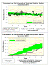
November 2010 Summary
Again with the hot temperatures and average precipitation
November kept the streak going for 2010 with an overall temperature that was a degree hotter than average. We have now seen above average temperatures for each of the 11 months of the year.
There was a regular hot streak from the 8th to the 14th and then a crazy 25 hours around the 22nd when it never went below 10 °C. On the graphs you can really see the difference in the daily cycle of temperature between the sunny/dry first half of the month and the cloudy/wet second half.
So after that incredibly dry first half of November, the second half made up for it getting us into the average range for the month. The total precipitation for the month was 72.7 mm with almost half of that coming on two wet days (16.8 on the 16th and 17.4 on the 30th).
We are now at 842.9 mm of precipitation for the year, a little above the average for this time which is 830.3 mm. It also looks likely that for the second year in row we will have an overall average year for precipitation.
Summary for November 2010:
Maximum Temperature 16.3 °C
Minimum Temperature -8.9 °C
Average Daily High Temperature 8.3 °C (Long term average 5.9 °C)
Average Daily Low Temperature -1.9 °C (Long term average -1.6 °C)
Total Precipitation 72.7 mm (Long term average 82.3 mm)
(Long term averages based on 1971-2000 data for the Waterloo Wellington Airport)
Sign up to get the monthly weather station summary by e-mail
Subscribe to:
Posts (Atom)


