We had a total of 26 cm from the storm on March 23rd.
This is the highest single day snowfall since March 9, 2007.
The total snowfall this season of 175 cm is now above the average of 160 cm.
If you are seeing this on Wednesday night you might want to get to shoveling as there is a very wet layer under the snow. Once that layer freezes it looks like it won't melt until late next week.
Wednesday, March 23, 2011
Monday, March 21, 2011
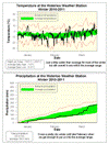
Winter 2010/2011 summary
A winter that was a bit colder and wetter than average
Overall the temperature was 0.6 degrees colder than average this winter, making it the coldest since 2005, but still within the average range. I think one reason it didn’t feel like a very cold winter was that it was never really cold for more than a few days in a row and the rest of the time it was just a few degrees below average. We also didn’t really see a mid-winter thaw, as between January 1st and February 13th it only went above zero for a single day.
For most of the winter the precipitation was very low, it wasn’t until late February that some very wet days put us back into the average range. The total precipitation was 220.4 mm compared to the average of 184.5 mm. This is almost double last year’s total of 113.2 mm, but not as much as the two years before that.
As always, it is hard to separate the snow during just the winter as opposed to the entire snowfall season. But, for just the winter we saw about 116 cm of snow compared to the average of 103 cm. However, it was really the 74 cm that came down in February that put us over the top.
Summary for Winter 2010/2011:
Maximum Temperature 13.6°C
Minimum Temperature -28.8°C
Average Daily High Temperature -1.8°C (Long term average -1.4°C)
Average Daily Low Temperature -10.6°C (Long term average -9.8°C)
Total Precipitation 220.4 mm (Long term average 184.5 mm)
(Long term averages based on 1971-2000 data for the Waterloo Wellington Airport)
Sign up to get the monthly weather station summary by e-mail
Sunday, March 6, 2011
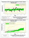
February 2011 summary
A month where both the temperature and precipitation were just within the average range
There were lots of dramatic temperature swings during the month with 20+ degree differences between the high and lows for a day commonplace. Although the temperature danced above and below average, overall the month was 0.7 degrees colder. However it is still considered an average month for temperature as it was within the average range.
The first week of the month had lots of precipitation and then it was then pretty dry until some rain on the last day. However, even though the total precipitation was 63.4 mm compared to the average of 51.3 mm, it was still (just barely) within the average range.
For the year so far, the amount of precipitation that we have seen (118.3 mm) is very close to the average at this time (115.7 mm).
It really has been a back-end loaded winter this year for snow as between October 1st and January 31st we had 71 cm of snow, but in February alone we had 56 cm. This is close to double to average snow in February of 30.6 cm.
Summary for February 2011:
Maximum Temperature 9.3°C
Minimum Temperature -23.4°C
Average Daily High Temperature -2.1°C (Long term average -1.9°C)
Average Daily Low Temperature -11.7°C (Long term average -10.5°C)
Total Precipitation 63.4 mm (Long term average 51.3 mm)
(Long term averages based on 1971-2000 data for the Waterloo Wellington Airport)
Sign up to get the monthly weather station summary by e-mail
Subscribe to:
Posts (Atom)


