Monday, April 25, 2011

Final numbers on the 2010-2011 snowfall season

Well I don't want to jinx it, but I think we can finally call an end to the 2010-2011 snowfall season.

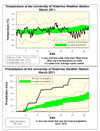
The final total was 177 cm compared to the average of 159.5 cm, it came down to the wire as the last real storm of the season on March 23/24 was what put us above the average.

From the graph (see below) you can see why I called it a "back end loaded" snowfall season. We were well below average until late January and then the switch got turned and we got storm after storm until mid-March.

The reason for this was that a zone of high pressure set up over Quebec during the fall and stayed around until late January. This meant that the jet stream was pushed further south and thus most of the storms were also deflected south of the Great Lakes. This pattern broke down in February and we returned to a more typical La Nina winter pattern with the jet stream coming over the Great Lakes. As storms are often carried along the jet stream it meant a lot more precipitation for us.

This pattern has continued on with what has been a pretty wet spring so far (and more rain in the forecast).

I also want to give a big thanks to my snow measurement volunteers: Melinda, Eric, and Jayson who helped gather the data during this year's snowfall season!


Sunday, April 10, 2011

2011 UW weather station contest ends!

Wow! I don't know if it has ever gone over 20 that fast before, it was only 11C out 2 hours before it went over 20C.

This year's winner is:

Janie Simpson

who correctly chose a time of 3:30 pm on April 10th as the first time the temperature at the UW weather station would go above 20C.

In second place we have:

Annarita Superina


Thanks to all 907 people who entered the contest, we hope you had fun with it and will enter again next year.

Once again we would like to thank The Waterloo Store who sponsored this year's prizes.

As well as taking home some cool prizes, the winners will also become members of the Waterloo Weather Station Contest Hall of Fame.

Thursday, April 7, 2011

Could the 2011 contest end this weekend?

The first above 20 degree temperatures are forecasted for this weekend.

Sunday, April 3, 2011

March 2011 summary


A cold March that was the wettest in almost 35 years

It was looking like an average month for temperature, but a very cold and clear last week put us 1.3 degrees below average. On some of these very cold days, the high temperature did not go above the average low temperature for the day.

The big story of the month was the 136.6 mm of total precipitation, this was almost twice the average of 70.6 mm and the wettest March since 1976 when we had 148.3 mm. There were two days with over 25 mm and three days in a row with over 15 mm. What
made it an even more astonishing total was that the last week of the month was dry.

With the biggest one day snowfall (26 cm) in three years happening on the 24th, it is not surprising that the month’s total snowfall of 50 cm was twice as much as the average of 24 cm.

This wet month put the amount of precipitation that we have seen for the year (254.8
mm), very much above average for the end of March (187.6 mm).


Summary for March 2011:
Maximum Temperature 13.6°C
Minimum Temperature -17.5°C
Average Daily High Temperature 2.4°C (Long term average 3.5°C)
Average Daily Low Temperature -7.1°C (Long term average -5.6°C)
Total Precipitation 136.6 mm (Long term average 70.6 mm)

(Long term averages based on 1971-2000 data for the Waterloo Wellington Airport)


Sign up to get the monthly weather station summary by e-mail