On the Monday of the Victoria Day weekend between 6:30 and 6:45 pm we got 14.5 mm of rain.
It is not a record for 15 minute precipitation at the University of Waterloo Weather Station (that was last year on July 23rd with 18.1 mm), but it very well could be the highest for this year.
Wednesday, May 25, 2011
Friday, May 20, 2011
Victoria Day Weekends
It seems that a lot of people think that Victoria Day weekend is always a particularly bad weather weekend. I have even written a blog entry on the subject here:
http://uwweatherstation.blogspot.com/2008/05/what-does-queen-victoria-have-against.html
This time let's look at precipitation, first off on average it rains about 1/3 of the days of May. So we would expect that on average it should rain one of the days of a 3 day long weekend. Over the past 12 years the breakdown of days with rain is as follows: 0 - 15%, 1 - 55%, 2-15%, 3-15%. I'm not sure of the actual probability distribution of such a series, but it seems pretty well what we would expect. It is also hard to make many conclusions with such a small sample.
Also interesting is that compared to other weekends (Sat, Sun, Mon) in May there is actually a better chance for 1 day or less of rain during the Victoria Day weekend. Or put another way there has been a greater chance for 2 or more days of rain during the other weekends of the month in the past 12 years.
And an update on temperatures during the Victoria Day holiday weekend, looking back at the last 12 of them (ie. the time the UW weather station has been around), it is true that about two-thirds have been colder than average. Random chance suggests we should be closer to 50/50. The forecast for this weekend looks like it might be the warmest in quite some time.
As I said in the last post about this topic, it is always the Victoria Day weekends that are really cold or wet that people seem to remember. Hopefully everyone can enjoy this weekend no matter what the weather.
Friday, May 13, 2011
Hottest day so far this year
When it got up to 26.4°C on Friday it was the hottest it has been so far this year. But that looks to be the last of the warm temperatures until the middle of next week.
Sunday, May 1, 2011
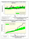
April 2011 Summary
The wettest April ever recorded
It may be surprising to some, but it worked out to be an average month for temperature. Overall it was actually 0.1 degrees above average, however as often happens the daytime highs were half a degree below average while the night time lows were about half a degree above. As people will naturally tend to notice the high temperature of the day, the feedback I got from people was that they were expecting it to be a colder than average month.
Although we had a stretch of 8 days where it didn’t go above 10°C, this was offset by a couple of warm days at the beginning of the month (including the 10th when the UW weather station contest was decided – congratulations to Janie Simpson on winning) and a few more warm days near the end.
Another thing that might have put people in a bad mood about the weather was the amount of precipitation. It turns out that the month of April was the wettest since records began in the area in 1914 with 136.5 mm coming down, this just barely beat 1921 when there was 135.9 mm.
Even more shocking is that on the 15th the total for the month was actually a bit below average at only 29.2 mm. But then storm after storm seemed to hit us with four days in the last half of April that recorded more than 15 mm, propelling us to the record breaking total.
Another wet month means that the amount of precipitation that we have seen for the year (391.4 mm) is very much above average for the end of April (264.4 mm). This is now the second wettest first 4 months of the year, just barely behind 1954 when we had 401.3 mm at this point.
The final total for the snowfall season of 2010/2011 was 177 cm compared to the average of 159.5 cm, it came down to the wire with the last real storm of the season on March 23/24 putting us above the average.
Summary for April 2011:
Maximum Temperature 22.3°C
Minimum Temperature -3.6°C
Average Daily High Temperature 10.9°C (Long term average 11.4°C)
Average Daily Low Temperature 1.3°C (Long term average 0.6°C)
Total Precipitation 136.5 mm (Long term average 76.9 mm)
(Long term averages based on 1971-2000 data for the Waterloo Wellington Airport)
Sign up to get the monthly weather station summary by e-mail
Subscribe to:
Posts (Atom)


