Saturday, June 25, 2011

Spring 2011 Summary


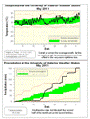
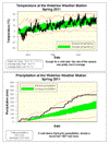
A very wet Spring with average temperatures


Apart from a cold start to the Spring it was actually pretty close to average for most of the season. The overall temperature was only slightly (0.2 degrees) lower than average. However, just looking at the daytime highs it was about a full degree less than average which is the coldest since 2003.

It was a very wet Spring with 338.2 mm of precipitation compared to the average of 219.5 mm. But this is not a record as we had 342.2 mm back in 1997 (that year saw over 100 mm during the first three weeks of June).

Summary for Spring 2011:
Maximum Temperature 32.0 °C
Minimum Temperature -17.5 °C
Average Daily High Temperature 14.9 °C (Long term average 15.9 °C)
Average Daily Low Temperature 5.0 °C (Long term average 4.4 °C)
Total Precipitation 338.2 mm (Long term average 219.5 mm)

(Long term averages based on 1971-2000 data for the Waterloo Wellington Airport)

Sign up to get the monthly weather station summary by e-mail

Wednesday, June 22, 2011

Quite an hour

Between 9:15 and 10:15 pm on Wednesday, June 22 the temperature dropped 6.5 degrees and we got 21 mm of precipitation.

Saturday, June 18, 2011

We are number one!

From my friend Rob Kuhn:

At 3 pm on Saturday, June 18th, Kitchener-Waterloo was the warmest place in Canada at 28.0°C

Wednesday, June 1, 2011

May 2011 Summary


The fifth wettest May on record, above average overall temperature, and the wettest ever start to the year


First off, how about that warm May! Hard to believe I know, but the daily low temperatures were a whopping 2.9 degrees above average for the month, this more than offset the daily highs that were 0.7 degrees below average. This means it was a little more than 1 degree above average overall for the month.

But of course people are going to remember the 4th when the high was only 7.0°C (the coldest daytime high in May since May 3rd, 2005) and the 16th when it only got up to 8.3°C.

One reason for the warmer than average nights was the amount of cloud cover we had during the month and the 17 days with some precipitation compared to an average of only 12, leading to...

The fifth wettest May since records began in the area at 150.3 mm, this actually ties us with May of 2000, but not close to the record back in 1956 when we had 202.2 mm. Just like April the first half of the month was very dry and it was the second half that put us well above average.

With the total precipitation for the year at 541.6 mm, not only is it well above the average (337.7) but it also way above the record which was 488.5 mm back in 1943.

Looking back now, it looks like April 30th will be the last frost day of the spring which is the earliest last frost date since 1999 when it was April 29th.


Summary for May 2011:
Maximum Temperature 31.1°C
Minimum Temperature 1.6°C
Average Daily High Temperature 18.2°C (Long term average 18.9°C)
Average Daily Low Temperature 9.4°C (Long term average 6.6°C)
Total Precipitation 150.3 mm (Long term average 75.7 mm)


(Long term averages based on 1971-2000 data for the Waterloo Wellington Airport)


Sign up to get the monthly weather station summary by e-mail