We have a winner!
Congratulations to Scott Bacon who was the winner of this year's UW weather station contest. In second place goes to Elisa McBride.
In celebration, anyone who is near the Waterloo campus can meet at E2-3321 at 4:30pm for a walk to the Grill Restaurant at the University Plaza for an ice cream cone (sadly, our prize budget does not allow us to buy ice cream for everyone).
The risk of the severe thunderstorm late this afternoon could also make for a dramatic walk.
Thursday, April 18, 2013
Thursday, April 4, 2013
Coldest temperature until the fall?
I will make the bold prediction that the -7.0C this morning will most likely be the coldest temperature we will see until next fall.
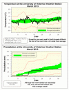
March 2013 Summary
A cold and dry March
Apart from a warm week where it hit double digits one day, the rest of the month was colder than average. However, it was never really that cold, so overall it was just 0.8 degrees below average.
It was reasonably wet the first half of the month, but then the taps turned off and only 2 mm of the month’s total of 43.5 mm fell during the last 10 days. As this was the first dry month, the amount of precipitation so far this year at 259.2 mm is still far above the average of 187.6 mm.
After a very snowy February, only 13 cm of the white stuff came down in March, well below the average of 21 cm. This puts the total for the snowfall season at 151 cm, which is just a bit below the average total of 159.5 cm.
Summary for March 2013:
Maximum Temperature 11.9°C
Minimum Temperature -15.3°C
Average Daily High Temperature 1.7°C (Long term average 3.5°C)
Average Daily Low Temperature -5.5°C (Long term average -5.6°C)
Total Precipitation 43.5 mm (Long term average 70.6 mm)
(Long term averages based on 1971-2000 data for the Waterloo Wellington Airport)
Subscribe to:
Posts (Atom)


