A soggy month with average temperatures and a very wet first half of 2013
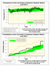
It was going along as a slightly cool month, but around the official start of summer it warmed up to put the overall average at 0.66°C higher than the average. However, that is still a few hundredths of a degree less than the 0.7°C we use to define the start of the above average temperature range.
And how did we come up with 0.7°C? Well the method we use at the UW weather station is to take 30 years of average monthly temperatures, order them smallest to largest, then the bottom 10 define the below average range and the top 10 define the above average range. The middle 10 are of course what defines the average range. There are differences between the high and low temperatures and differences for each month, but we just simplify things and use the average value of 0.7°C for all months.
For precipitation, it was looking like a typical month until we got hit with the largest one day precipitation in over a year. On the 28th we received 43.8 mm, with 16.8 mm of that coming between 2:15 and 2:45 pm. However, as a result of the type of precipitation we get in the area during the summer, there were areas that likely had even more intense precipitation that caused many flooded streets and parking lots in the area.
The total for the month was 120.9 mm compared to an average of 80 mm. Although this is well above average, we only have to go back to 2010 to find a wetter June when we had 130.3 mm.
Now that we are halfway through the year, we can see how it stacks up: For temperature it was 0.43 C above average, nothing too significant there. However, the 568.8 mm of precipitation is the 4th wettest first 6 months of the year, only behind 1947 (624.8 mm), 2011 (602.0 mm), and 1953 (583.9 mm). Also quite a contrast to last year when we only had 316.3 mm.
Summary for June 2013:
Maximum Temperature 30.5°C
Minimum Temperature 5.5°C
Average Daily High Temperature 22.8°C (Long term average 23.6°C)
Average Daily Low Temperature 13.4°C (Long term average 11.3°C)
Total Precipitation 120.9 mm (Long term average 80.0 mm)
(Long term averages based on 1971-2000 data for the Waterloo Wellington Airport)