Tuesday, February 18, 2014
Above zero?
If the temperature goes above zero in the next few days it will be for only the second time since January 14th. Although the 0.3°C on Feb 1 was hardly a real break from the cold.
Monday, February 3, 2014
January 2014 Summary
A very cold January with average precipitation
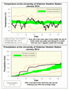
It was certainly a cold month that, even with almost a week of above average temperatures, ended up being 3 degrees colder than average. This was quite a contrast to the last 2 years when it was 3 degrees above.
The low temperature on the morning of January 22nd of -29.8°C was the coldest we have seen since January 28th of 2005 when it was -30.5°C. But perhaps even more interesting was that on January 7th the temperature only got up to -18.7°C, this was the lowest daily high temperature since January 19th, 1994.
A lot of the precipitation for the month came as rain during the warm up we had on the 11th, while the total of 74.1 mm was higher than the average of 64.4 mm but till within the average range.
The snowfall for January was 54.0 cm compared to the average of 43.5 cm, for the snowfall season going back to last year what we have seen so far (103.5 cm) is pretty close to the average (108.0 cm). However, since we haven’t had a snow reset this year a lot of the snow that has fallen is still there, so it might seem like we are having a bigger snow season that we really are.
Summary for January 2014:
Maximum Temperature 5.8°C
Minimum Temperature -29.8°C
Average Daily High Temperature -6.0°C (Long term average -3.1°C)
Average Daily Low Temperature -14.7°C (Long term average -11.1°C)
Total Precipitation 74.1 mm (Long term average 64.4 mm)
(Long term averages based on 1971-2000 data for the Waterloo Wellington Airport)
Subscribe to:
Posts (Atom)


