Saturday, December 3, 2022

November 2022 Summary

A warm and dry November

It was a tale of two parts of the month in terms of temperature, the first 12 days had an average high of 16.4°C while for the rest of the month the average was only 3.7°C.  That first part was warm enough that the overall temperature was 1.8 degrees above average, which made it the most above average of any month this year.

It was also dry during that first half of the month, with only 15 mm in the first 15 days.  Although it was a bit wetter in the second half the total only got to 48.6 mm, a lot less than the average of 87.1 mm, and the driest November in the last 10 years.

The total precipitation for the year of 507.3 mm is well below the average of 832.9 mm.  This is now the fourth driest first 11 months of the year in the history of records in the region, which go back to 1917.

The total snowfall of 16.5 cm was a bit more than the average of 13 cm for November.

Summary for November 2022:

Maximum Temperature 23.4°C
Minimum Temperature -9.1°C
Average Daily High Temperature 8.7°C (Long term average 6.3°C)
Average Daily Low Temperature -0.3°C (Long term average -1.4°C)
Total Precipitation 48.6 mm (Long term average 87.1 mm)

(Long term averages based on 1981-2010 data for the Waterloo-Wellington Airport)


Sunday, November 6, 2022

October 2022 Summary

The driest October in 14 years with average temperatures

With clear nights, it was one of those months where the daytime highs were almost 2 degrees above average but the nighttime lows were over half a degree below average.  Put that together and it comes out to an overall average of 0.7 degrees above average, keeping it just within the average range.

During the morning of October 2nd the temperature went below zero for the first time since the spring.  This is almost 2 weeks earlier than the average and ties 2003 for the earliest we have seen at the UW Weather Station.

With no precipitation for the first 11 days of the month, it is not surprising that the total for the month only got to 49.8 mm, which is below the average of 67.4 mm.  This made it the driest since 2008 when we saw 45.0 mm.

Another dry month resulted in the total precipitation since January (458.7 mm) getting even more below the average for this time of year (750.6 mm).  This is now the fourth driest first 10 months of the year that we have seen in the over 100 years of weather records in the region.

Summary for October 2022:

Maximum Temperature 24.3°C
Minimum Temperature -3.1°C
Average Daily High Temperature 15.4°C (Long term average 13.5°C)
Average Daily Low Temperature 2.3°C (Long term average 2.9°C)
Total Precipitation 49.8 mm (Long term average 67.4 mm)

(Long term averages based on 1981-2010 data for the Waterloo-Wellington Airport)


Monday, October 3, 2022

September 2022 Summary

A warm and very dry September

Although it cooled down the last week of the month, the rest of the month was very warm with even a couple of days above 30°C (we usually only see one of those every 2 years).  This resulted in an overall average temperature almost 1.5 degrees above average.

With only 22.2 mm of precipitation during this was the fourth driest September in the weather records in the region which go back to 1914.

This very dry month put the total for the year of 408.9 mm even more below the average of 683.5 mm.

Summary for September 2022:

Maximum Temperature 31.1°C
Minimum Temperature 0.4°C
Average Daily High Temperature 22.7°C (Long term average 20.4°C)
Average Daily Low Temperature 9.1°C (Long term average 8.6°C)
Total Precipitation 22.2 mm (Long term average 87.8 mm)

(Long term averages based on 1981-2010 data for the Waterloo-Wellington Airport)


Thursday, September 15, 2022

August 2022 Summary

A hot month that completed the second driest summer on record

After 2 months that were colder than average, the month of August came in a bit more than 1 degree higher than average.  This is not surprising with 5 days above 30°C compared to the average of only 2 and only a few very cold days.

We only received 44.8 mm of precipitation, which is just a little more than half the average of 83.9 mm.  This made it the driest August since 2010 and put the total precipitation so far in 2022 of 386.7 mm closer to the average of 596.0 mm.  This is the sixth driest first 8 months of the year that we have seen in the region.

The total precipitation for this year’s meteorological summer (June, July, and August) was 112.1 mm.  This is the second lowest total precipitation for these months in the over 100 year history of records in the region, the only drier summer was in 2007 when there was only 74.5 mm.


Summary for August 2022:

Maximum Temperature 31.5°C
Minimum Temperature 6.4°C
Average Daily High Temperature 27.3°C (Long term average 24.8°C)
Average Daily Low Temperature 12.5°C (Long term average 12.9°C)
Total Precipitation 44.8 mm (Long term average 83.9 mm)

(Long term averages based on 1981-2010 data for the Waterloo-Wellington Airport)

Sunday, August 7, 2022

July 2022 Summary

The fifth driest July ever recorded in the region and the driest since 2001

**Note that the UW Weather Station’s main controller stopped working at the end of January, we have received a replacement and are currently setting it up, the data for this month’s summary comes from readings taken at the Waterloo Regional Airport**

For the second month in a row, the much above average daytime temperatures were balanced out by the much below average nighttime temperatures.  The result was an overall temperature that was just 0.1 degrees below average, which is within the average range.  

Although there were 8 days at or above 30°C compared to an average of 3.6, including 6 of them in a row, it was still the coolest July since 2014.  

As always, the lawns and gardens around town showed just how dry it was during the month.  With only 18.7 mm of total precipitation, it was the fifth driest July in the region since began over 100 years ago (with a special shout out to 1916 when only 1.8 mm was recorded, although the 3rd day of the month was missing) and the driest since 2001.

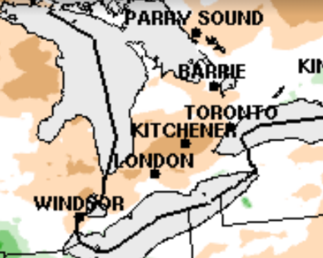
Also, there was some talk during the month about storm systems which came through Southern Ontario that would split or fade out before hitting Waterloo region.  Well according to the map below of the precipitation anomaly from Environment and Climate Change Canada for July, there is a bulls-eye of brown indicating that our region was the most below average in all of Southern Ontario.  So maybe it wasn’t just our imagination.

The very dry month put the total for the year of 341.9 mm now even further below the average of 509.0 mm.


Summary for July 2022:

Maximum Temperature 33.6°C
Minimum Temperature 7.1°C
Average Daily High Temperature 27.8°C (Long term average 26.0°C)
Average Daily Low Temperature 12.1°C (Long term average 14.0°C)
Total Precipitation 18.7 mm (Long term average 98.6 mm)

(Long term averages based on 1981-2010 data for the Waterloo-Wellington Airport)