Monday, August 2, 2021

July 2021 Summary

An average month for both temperature and precipitation

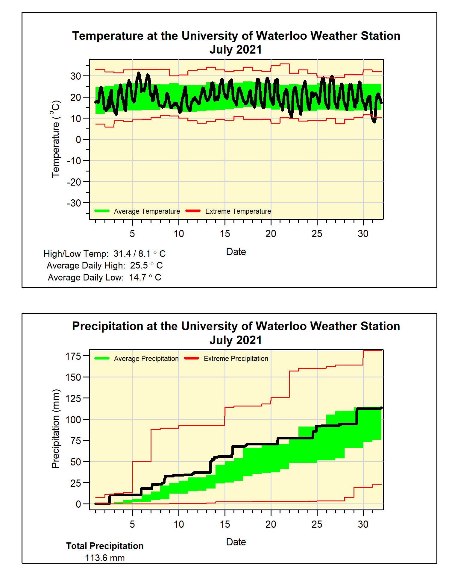
Although the month started off with a bit of a hot streak, this was followed by some cooler temperatures and the rest of the month didn’t see many extremes.  The resulted in an overall temperature that was just a bit (0.2 degrees) higher than average, but well within the average range.  This does make it the coldest July in 6 years and there has only been 1 colder than average July in the last 12 years.

There was pretty consistent precipitation throughout the month, but in the end the 113.6 mm, although more than the 98.6 mm average, was less than a millimetre from putting it into the above average range.  However, it was the wettest July in the last 7 years.

After a dry start to the year, the most recent month and half has started to make up for it, the total precipitation so far this year of 454.9 mm is now closer to the average of 509.0 mm.

Summary for July 2021:
Maximum Temperature 31.4°C
Minimum Temperature 8.1°C
Average Daily High Temperature 25.5°C (Long term average 26.0°C)
Average Daily Low Temperature 14.8°C (Long term average 14.0°C)
Total Precipitation 113.6 mm (Long term average 98.6 mm)
(Long term averages based on 1981-2010 data for the Waterloo-Wellington Airport)


Thursday, July 1, 2021

June 2021 Summary

A very hot June with above average precipitation

There were lots of really hot days during the month and only a couple of cooler ones, this resulted in an overall temperature that was 3 degrees above average.  This was the warmest June since 2005 and the 5th warmest in the weather records in the region that go back to 1914.

A lot of this heat came at the beginning of the month, with 4 days over 30°C and 3 of those on consecutive days.  Although it is not unusual to see days this hot during June, typically they occur later in the month.  The last time there were 3 days in a row above 30°C in the first half of the month was back in 2005.

It was looking like it was going to be an average month for precipitation, but that all changed in the last 7 days.  During the last week of June there was one storm that resulted in 37.8 mm and then another a few days later that dropped 25.4 mm.  The total for the month was 117.4 mm, making it the wettest month since we got 154.7 mm in January of 2020.

Even with this very wet month, because it has been so dry this year, the total precipitation we have seen in the first half of the year of 341.3 mm is well below the average total of 416.1 mm.  

Summary for June 2021:

Maximum Temperature 31.4°C
Minimum Temperature 4.0°C
Average Daily High Temperature 26.3°C (Long term average 23.6°C)
Average Daily Low Temperature 14.9°C (Long term average 11.5°C)
Total Precipitation 117.4 mm (Long term average 82.4 mm)

(Long term averages based on 1981-2010 data for the Waterloo-Wellington Airport)


Tuesday, June 1, 2021

May 2021 Summary

A very dry May with average temperatures 

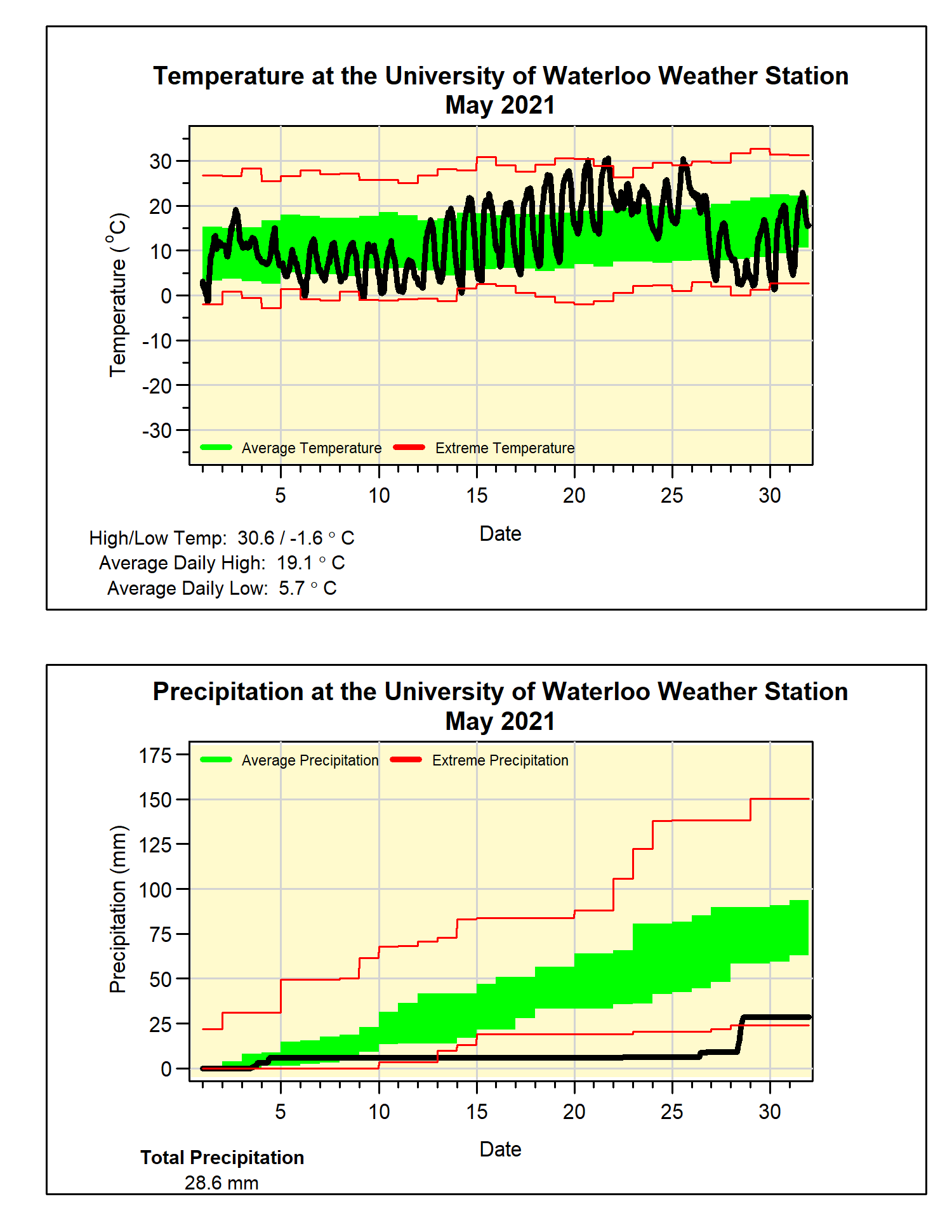
As often happens with months that have periods of cold temperatures (the start of May) and hot temperatures (the middle of May), the overall temperature turns out to be close to average.  In this case very close, with the month coming in at just 0.1 degrees below average.  

Assuming we have seen the last below zero temperature until the fall, the last freezing day was May 9th, this is just a couple of days later than the average in the last 20 years.  On the other end of the scale, there were 3 days of temperatures over 30°C during the month, when we typically we only average one of those days every other year.

With a period of over 2 weeks of no measureable precipitation, it was looking like it might be the driest May in the over 100 year of weather records in the region.  However, the wettest single day (19.6 mm) since mid-April on the 28th brought the total up to 28.6 mm for the month.  It was still the driest May since 2005, but only the 9th driest in local weather data records.  

This dry month puts the total for the year so far at 223.9 mm, well below the average of 340.2 mm.

Summary for May 2021:
Maximum Temperature 30.6°C
Minimum Temperature -1.6°C
Average Daily High Temperature 19.1°C (Long term average 18.5°C)
Average Daily Low Temperature 5.7°C (Long term average 6.4°C)
Total Precipitation 28.6 mm (Long term average 82.3 mm)

(Long term averages based on 1981-2010 data for the Waterloo-Wellington Airport)


Sunday, May 2, 2021

April 2021 Summary

A warm April with just barely above average precipitation 

Even with a few cold days scattered throughout the month, the week or so of warm days at the beginning of the month was enough to put the overall temperature at 1.3 degrees above average.  This marks only the second warmer than average month of April in the last 11 years.

At 12:30 pm on April 8th, the temperature went above 20°C for the first time this year ending the UW Weather Station Contest for 2021, this was over a month earlier than last year’s date of May 13th.

Over half of the precipitation for the month came during 2 really wet days (the 11th and 12th) when 51.0 mm came down.  The total for the month was 86.0 mm, putting it just into the above average range.

The slightly above average precipitation this month brought the total of the year (195.3 mm) a bit closer to the average at this time of year (264.4 mm).


Summary for April 2021:
Maximum Temperature 23.1°C
Minimum Temperature -6.5°C
Average Daily High Temperature 12.8°C (Long term average 11.5°C)
Average Daily Low Temperature 2.1°C (Long term average 0.8°C)
Total Precipitation 86.0 mm (Long term average 74.5 mm)

(Long term averages based on 1981-2010 data for the Waterloo-Wellington Airport)


Friday, April 2, 2021

March 2021 Summary

A warm March with barely average precipitation

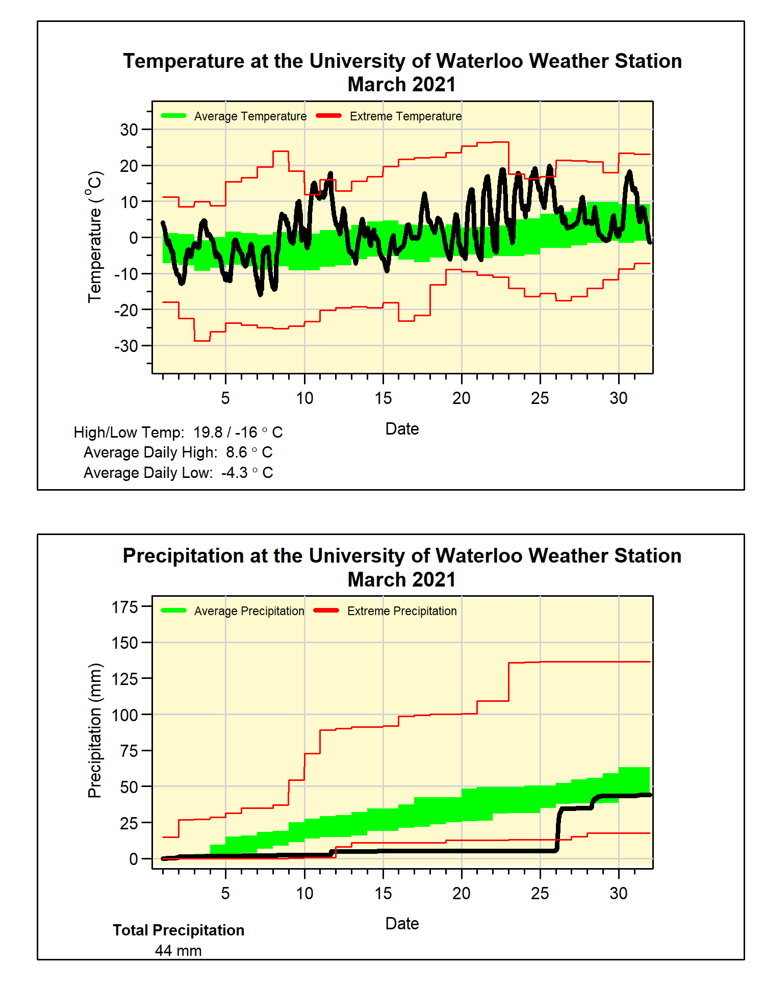
There were never any very cold temperatures during March and along with a few days that got close, I mean really close, to 20°C, the result was an overall temperature over 3 degrees above average.  This made it the warmest March in the last 9 years since that very memorable one back in 2012.

Over half the month’s precipitation came on one day, when we saw 28.6 mm on the 26th, while the rest of the month was very dry.  The total of 44.0 mm was just barely enough to get it into the average range, even though it was much less than the average of 61.0 mm.  This year has started out very dry with only 109.3 mm of precipitation compared to an average of 187.6 mm for this time of year.

With the combination of warm temperatures and low precipitation it shouldn’t surprise anyone that we only got 1.5 cm of snow during March.  This of course is much less than the 26.5 cm of snow that we get on average.

If we don’t get any more this year, the total for the snowfall season will stay at 129.5 cm, well below the average of 159.7 cm.  However, it may have felt like we had more snow this winter as it stayed cold enough from late December to early March not to melt all the snow we received.  We never got the typical mid-winter snow reset and thus the snow piled up into large mountains beside our driveways making it seem like a snowy winter, when really it wasn’t.

Summary for March 2021:
Maximum Temperature 19.8°C
Minimum Temperature -16.0°C
Average Daily High Temperature 8.6°C (Long term average 3.6°C)
Average Daily Low Temperature -4.3°C (Long term average -5.6°C)
Total Precipitation 44.0 mm (Long term average 61.0 mm)

(Long term averages based on 1981-2010 data for the Waterloo-Wellington Airport)