Monday, December 21, 2009

Fall 2009 Summary

A warm fall with average precipitation and not a lot of snow

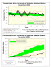
This fall really showed that you can’t take what happens during the first month and extrapolate it to the rest of the season. Up to mid-October it was very cold and very wet, however since then it has turned around.

For temperature, November was quite a bit warmer than average and the beginning of December was moderately warmer making the overall season a full degree above average.

The most surprising thing about the temperature was that the lowest we saw was only -11.9 °C, where we often see it dip down approaching -20 °C or below during the season. This was the highest low temperature of the season since 2001 when it only got down to -8.6 °C.

Looking at precipitation, it really dried out after that wet start and the final total (218.3 mm) was very close to the average (220.9 mm). Of course everybody wants to know about the snow, and in this regard the total for the season (25 cm) was a lot less than last year (96 cm) and the average for fall (40 cm).

Summary for Fall 2009:
Maximum Temperature 24.1 °C
Minimum Temperature -11.9 °C
Average Daily High Temperature 8.8 °C (Long term average 8.3 °C)
Average Daily Low Temperature 1.0 °C (Long term average -0.5 °C)
Total Precipitation 218.3 mm (Long term average 220.9 mm)

(Long term averages based on 1970-2000 data for the Waterloo Wellington Airport)


Sign up to get the monthly weather station summary by e-mail

Saturday, December 19, 2009

Almost the end of fall

Winter officially starts on Monday, so it's time to start looking at the stats from the fall.

It is looking like it will come out to be a bit warmer than average and pretty much average for precipitation.

Sunday, December 13, 2009

A cold day

It was a really cold day on Friday with the daytime high only going up to -8.2°C, this was the lowest high temperature since March 2nd.

Combined with the wind it felt like it was around -20 most of the day.

Monday, December 7, 2009

Welcome to the earliest sunset of the year

Although there is no doubt that the day with the least total amount of daylight is December 21st (the winter solstice), the earliest sunset of the year actually occurs on December 8th. The reason has to do with something called the Equation of Time and depends on the tilt of the earth and the shape of its orbit around the sun. You can read the detailed explanation of why here

 Although the time the sun sets will be getting later from now on until the summer, the sunrise will continue to be later and later until early January. Also remember that at this time of the year there is usually only a few seconds to a minute difference between the sunrise and sunset times from day to day. 

So by the end of the month the sunset will only be about 10 minutes later than it is today.

Friday, December 4, 2009

There goes the streak

Well that was a cold day as it only got up to 0.3°C on December 4th (but that happened at 4 am ** edit make that 1 am ** so you might have missed it).

Not only was this the lowest daytime high since April 7th, but it also broke a stretch of 27 straight days with above average daytime highs.

Tuesday, December 1, 2009

November 2009 Summary

A very warm and dry month with the lowest snowfall ever (possibly, maybe?)

November started out with 6 colder than average days, however that changed when the rest of the month (24 days) all came in warmer than average. Overall it was an amazing 3 degrees above average making it the warmest November since 2001. It was also the most above average month since January of 2008.

It was also the driest month since 2001 with only 34.8 mm of precipitation including a dry stretch that lasted 12 days. Almost all of it came in the form of rain as we only recorded a single day with some trace snow (November 27th).

So now the big question: was this the least amount of snow ever in November for the region? Unfortunately, it is not an easy question to answer as it all depends on how you interpret the trace readings of snow you often get at this time of year. A trace amount of snow is when there is less than 0.5 cm but definitely some on the ground. There have been many years with less than 1 cm of snow in November, for instance in 2006 we only had 0.5 cm.

Looking back in the long term records the last time there was 0 cm of snow was back in 1963. However, the daily records show that there were 6 days with trace snow in 1963 and going back further I was never able to find a year with 0 cm of snow and less than 3 days of trace snow. So using that as a criterion we can say that this November had the least amount of snow of November in the recorded history of the region which goes back to 1914.

The total precipitation for the year (819.5 mm) is very close to the average (830.3 mm). So unless we get less than 15 mm or over 350 mm in December, this year will end up in the average range for precipitation.


Summary for November 2009:
Maximum Temperature 18.0 °C
Minimum Temperature -5.0 °C
Average Daily High Temperature 9.3 °C (Long term average 5.9 °C)
Average Daily Low Temperature 0.9 °C (Long term average -1.6 °C)
Total Precipitation 34.8 mm (Long term average 82.3 mm)

(Long term averages based on 1971-2000 data for the Waterloo Wellington Airport)


Sign up to get the monthly weather station summary by e-mail