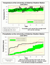
At two and a half degrees above average, it was a very hot month. However the longest hot streak only lasted for 3 days so we never had to wait long for some relief from the heat. Also, as hot as June was, you only have to go back to 2005 to find a hotter one.
So although the temperatures we saw this month were not all that noteworthy, the cumulative effect of many months of above average temperatures has made this the hottest 12 month period since records began in the area almost 100 years ago.
Until recently the warmest 12 month period in the region was the calendar year of 1998 when the average temperature was 8.98°C. With the warm winter we had, combined with the record breaking extremely hot March, the average for July 2011 to June 2012 was 9.30°C. This solidly beats 1988 and is well above the 1971-2000 average annual temperature of 6.7°C.
It was a crazy rainy start to the month with the wettest single day of the year so far (56.7 mm) happening June first. This was almost as much as during the entire months of April and May combined (57.7 mm). The rest of the month only had 50.9 mm and the last half of the month was actually relatively dry.
With this wet month, the gap has closed between the measured total precipitation so far this year (316.3 mm) and the average (416.6 mm), but overall the first half of the year was still very dry.
Summary for June 2012:
Maximum Temperature 32.5°C
Minimum Temperature 7.1°C
Average Daily High Temperature 24.9°C (Long term average 23.5°C)
Average Daily Low Temperature 13.3°C (Long term average 11.2°C)
Total Precipitation 107.6 mm (Long term average 80.0 mm)
(Long term averages based on 1971-2000 data for the Waterloo Wellington Airport)