Whatever the high temperature gets to Thursday, October 25th (I have seen forecasts of 20 to 22), there is a high probability that it will be the warmest temperature we see for some time, possibly all the way until next spring.
Although temperatures like this have been seen in November, it gets less and less likely the later we get in the year.
So hopefully everybody can get out and enjoy the day.
Wednesday, October 24, 2012
Sunday, October 14, 2012
Frost-free season over
At 9:30 pm on October 12th the temperature went down to -0.2 °C marking the end of the frost-free season. This is pretty much the average data of first frost in the last 10 years. Note that on the evening of October 7th the weather station run by Environment Canada at the Waterloo-Wellington airport first went below zero, but the UW weather station didn't quite get that low.
The start of the frost-free season was on May 1 of this year, making the length of the season a total of 165 days. This is about a week longer than the average frost-free season in the last 10 years.
The start of the frost-free season was on May 1 of this year, making the length of the season a total of 165 days. This is about a week longer than the average frost-free season in the last 10 years.
Friday, October 5, 2012
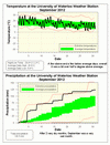
September 2012 Summary
Finally a wet month and the warm trend continues
Although not as warm as previous months, the temperature for September was still 0.7 degrees above average. This now marks a full year and a half (18 months) where the monthly overall temperature has been above average.
The real story of the month was a break from the very dry conditions we have seen since early June. The almost 40 mm we got on the 4th of the month was more that the entire month of July.
The last time we had this much precipitation in a single month (120.5 mm) was back in October of 2011 (141.9 mm). It was also only the second above average month of the year.
The wet month got the total for the year (522.1 mm) a bit closer to the average (685.2 mm) but it has still been a dry year.
Summary for September 2012:
Maximum Temperature 29.4°C
Minimum Temperature 2.2°C
Average Daily High Temperature 20.6°C (Long term average 20.2°C)
Average Daily Low Temperature 9.4°C (Long term average 8.5°C)
Total Precipitation 120.5 mm (Long term average 87.5 mm)
(Long term averages based on 1971-2000 data for the Waterloo Wellington Airport)
Subscribe to:
Posts (Atom)


