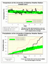
The second wettest October on record that was also warm
Although the daily average high temperatures were close to average, the generally cloudy conditions during the month didn’t let it get that cold at night. As a result, the daily low average temperatures were 2 degrees higher than the long-term average. This marks the 19th month in a row with above average overall temperatures.
The story of the month was the incredible amount of precipitation, at 156.4 mm it was the second wettest October since records began in the area in 1914 (the wettest was back in 1954 with 190.8 mm). It was consistently wet with 6 days where over 10 mm fell, a
couple over 20 mm and the longest dry period only lasted 2 days.
Obviously with a month as wet as this, the total precipitation for the year at 679.0 mm is now getting closer to the average for this point of the year of 754.9 mm.
Summary for October 2012:
Maximum Temperature 23.6°C
Minimum Temperature -3.5°C
Average Daily High Temperature 13.5°C (Long term average 13.5°C)
Average Daily Low Temperature 5.2°C (Long term average 3.0°C)
Total Precipitation 156.4 mm (Long term average 67.1 mm)
(Long term averages based on 1971-2000 data for the Waterloo Wellington Airport)