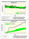
It might be hard to believe with the cold end to the month, but overall it was almost 2 degrees warmer than average. There was quite a difference between the first 10 days of the month, at about 2 degrees below average, and the first 20 days, which were about 4 degrees above average.
The temperature went below zero for the first time since the spring during the morning of October 29th. The last freezing temperature we saw was back on April 26th, resulting in a growing season of 186 days, the longest we have seen at the UW weather station.
Back in July, the 173.0 mm was the most ever seen in the 15 year history of the UW weather station, but now October comes along with 181.4 mm. The last day was the wettest of the month (37.3 mm) and also the wettest single October day in UW weather station history. Incidentally, it was also the second wettest October since records began in the region about 100 yeas ago (wettest was 1958 with 190.8 mm).
After such a wet of month, this is now far and away the most precipitation in the first 10 months of the year and we are closing in on the wettest year. At the end of October we are at 1085.7 mm, which means we only need about 100 mm in the last 2 months to make it the wettest year ever in the area.
Summary for October 2013:
Maximum Temperature 24.0°C
Minimum Temperature -3.2°C
Average Daily High Temperature 14.9°C (Long term average 13.2°C)
Average Daily Low Temperature 5.1°C (Long term average 2.9°C)
Total Precipitation 181.4 mm (Long term average 67.1 mm)
(Long term averages based on 1971-2000 data for the Waterloo Wellington Airport)


