The high of 14.2°C on January 30th was the 2nd warmest January day we have ever seen in the region since records began back in 1914, well at least tied for the 2nd warmest.
The warmest January day was 14.9°C on January 13th, 2005 and the second warmest was also 14.2°C on January 14th, 1995.
Thursday, January 31, 2013
Monday, January 28, 2013
2 warm days in a row
If we get the predicted 2 days in a row with temperatures above 10 degrees on Tuesday and Wednesday, it would be the first time this would happen during the month of January since 2008.
Wednesday, January 23, 2013
Coldest day for almost 2 years
The -20.0°C we saw on the morning of Wednesday, January 23rd. This was colder than any day in 2012 and you have to back to the low of -20.2°C on February 23rd of 2011 to find a colder day. (OK it was a month less than 2 years, but still a pretty long time)
Tuesday, January 8, 2013
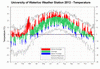
2012 Summary
The weather story for the region in 2012 was the consistent warmth we saw during the entire year. In particular, the incredibly hot March that was over 7.5 degrees warmer than average making it the warmest ever in the region since records began back in 1914. It also included a week of temperatures above 20 degrees and the high temperature of 26.4°C on the 22nd was the warmest March temperature on record.
Although many people enjoyed this early taste of spring, many trees and plants that started to come out of hibernation during this period were damaged when more typical temperatures came back in April.
Overall, it was the second warmest year we have seen in the region with an average temperature of 8.93°C. This was only slightly less than the record set back in 1998 of 8.98°C. However, the period between July of 2011 and June of 2012 was the warmest 12 month period ever with an average temperature of 9.33°C.
Other notable temperature stories from the year were: February being the second warmest on record, only 2 colder than average days in July, and November being the end of 19 months in a row of warmer than average months.
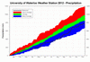
On the precipitation side, 6 of the 7 months between February to August were all drier than average, so although we had a few wetter than average months during the fall, overall it was a dry year. We had 782.7 mm compared to the average of 904.0 mm making it the driest year since 2007. It may have been a close to a record dry year if not for September at 120.5 mm and the second wettest October ever in the region at 156.4 mm.
The wettest day of the year was June 1st with 56.7 mm of precipitation, this was more than came down during any month between February to August (if you take the first out of the total for June).
With the warm temperatures and low precipitation it is not surprising that the snowfall total at 86.5 cm was a just a little over half of the average of 159.5 cm. This was the least snowy calendar year since 1982 when we only had 77.8 cm.
One thing to keep in mind is that the kind of year we saw in 2012 might be something we will have to get used to in the future. According to many of the future climate models what we saw this year (warmer temperatures and drier summers) will be more common. Not that every year will be exactly like this, but the unique weather this year may not be so unique in the future.
Summary for 2012 (averages are calculated from 1971-2000 data for the Waterloo-Wellington Airport):
Average Daily High Temperature: 14.31 °C (average 11.89 °C)
Average Daily Low Temperature: 4.32 °C (average 1.71 °C)
Total Precipitation: 782.7 mm (average 904.0 mm)
Click on the image below to see the temperature chart:
Click on the image below to see the precipitation chart:
Wednesday, January 2, 2013
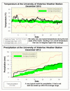
December 2012 Summary
December was warm with average precipitation
The month ended on a cold note, but this was more than offset by an extremely warm start, making for an overall temperature that was 3.5 degrees above average. The high temperature of 14.7°C on the 4th was the warmest December temperature since 2001 (16.7°C on the 5th).
After a wet start (25.6 mm on the 2nd) the rest of the month had lots of days with some precipitation, however the total of 81.8 mm was still within the average range. We saw 16.5 cm of snow during the month which is less than half of the average of 38.5 cm.
Summary for December 2012:
Maximum Temperature 14.7°C
Minimum Temperature -11.6°C
Average Daily High Temperature 2.8°C (Long term average -0.4°C)
Average Daily Low Temperature -3.2°C (Long term average -7.5°C)
Total Precipitation 81.8 mm (Long term average 71.1 mm)
(Long term averages based on 1971-2000 data for the Waterloo Wellington Airport)
Subscribe to:
Posts (Atom)


