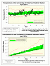
The overall temperature in April was just cold enough to make it below average, but it was the closest to the average in 6 months at 0.8 degrees lower. Looking at the graph you can see the incredibly steady (almost) 48 hours drop in temperature from the high of 19.8°C on the14th to the low of -9.0°C on the 16th.
Up until the last two days it might have been a below average month for precipitation, but those two days pushed the total of 90.9 mm right to the top of the average range (the top of the range is 91.0 mm). The total for the year so far is 214.7 mm which is somewhat below the average at this time of 264.4 mm.
The 3.5 cm of snow in April topped off the snowfall season at 167.5 cm, which was really not that much more than the average of 159.5 cm. But, as has been previously noted it might have seemed like a lot more as we didn’t get a mid-winter thaw.
Summary for April 2014:
Maximum Temperature 22.3°C
Minimum Temperature -9.0°C
Average Daily High Temperature 10.6°C (Long term average 11.4°C)
Average Daily Low Temperature -0.2°C (Long term average 0.6°C)
Total Precipitation 90.9 mm (Long term average 76.9 mm)
(Long term averages based on 1971-2000 data for the Waterloo Wellington Airport)


