The wettest month in 17 years with above average temperatures
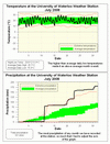
We had 2 very significant rainfall events during the month, the first occurred on the morning of July 11th between 3 and 9 am when 78.0 mm of rain fell. This was the highest one day total precipitation in the 10 year history of the weather station and you have to go back to July 7, 1991 to find a higher daily total (82.0 mm).
According to the Ministry of Transportation standards this is the kind of 6 hour storm that is likely to occur only once every 25 years. (see more information about this storm along with pictures here: uwweatherstation.blogspot.com/2008/07/record-rainfall.html )
The second significant rainfall event came during the evening of July 22nd between 7:30 and 7:45 pm when got 23.0 mm of rain. Again this was the highest 15 minute total in UW weather station history, but I don't know of any other local station that publishes 15 minute data, so I don't know how long since we have seen an event of that magnitude. However, using the MTO standards it would be classified as a 1 in 10 year storm, hence not quite as significant as the July 11th storm. (see more info here: uwweatherstation.blogspot.com/2008/07/another-week-another-record-rainfall.html )
Hardly surprising then that the overall precipitation for the month was the most we have seen at the station for any month (181.0 mm). We have to go back to July of 1991 at the Waterloo-Wellington airport station to find a month that had more (182.6 mm).
An intense storm on the 30th put the month into 5th place for the highest July precipitation total since records began in the region in 1915 (number one is 1988 when there was 223.2 mm).
The combined June/July precipitation (287.4 mm) was the third highest of all time, here the highest total goes back to 1947 when the combined June/July precipitation was 309.4 mm.
We have had 667.5 mm of precipitation so far in 2008, the average for this time of year is 506.0 mm. Last year at this time we only had 354.5 mm, thus this year we have had almost twice as much precipitation as 2007.
Not much to stay temperature-wise about July, it averaged out to 0.7 degrees above average which is just enough to call it an above average month. Just like June the daily low temperatures were very much above average while the daily high temperatures were actually slightly below average.
Thanks to Prof. Bryan Tolson for getting me the MTO data.
Environment Canada prediction of temperature for the month: Below average
Actual Temperature: Above Average
Summary for July 2008:
Maximum Temperature 29.6 °C
Minimum Temperature 8.3 °C
Average Daily High Temperature 25.7 °C (Long term average 25.9 °C)
Average Daily Low Temperature 15.3 °C (Long term average 13.7 °C)
Total Precipitation 181.0 mm (Long term average 92.9 mm)
(Long term averages based on 1970-2000 data for the Waterloo Wellington Airport)
Click on the image below to see the monthly chart:

Sign up to get the monthly weather station summary by e-mail


3 comments:
It is interesting to note that the previous extreme precipitation line followed very closely with the one established this year. Storms happened roughly, on the same day and had about the same amount of total precipitation.
2007 was one of Waterloo's driest summers on record, 2008, one of its wettest - double the 30-yr normal.
Let's see if August will shape up to be the same.
Janak has a wide range of total station series for sale in Delhi/NCR, India like RTS700 series Total Station 810 Series, Total Station 680 Series, Total Station 650 Series.
Post a Comment