Our low temperature on the morning of Wednesday, May 28th was 0.014°C at 6:00 am, thus we just managed to stay above freezing.
However, remember that the temperature at the UW weather station is measured at 2 m above the ground (this is the worldwide standard). So your plants, that are most likely closer to the ground, may have some frost damage.
If you did inspect you annuals this morning and can report on the frost damage please leave a comment below.
At the Environment Canada weather station at the Waterloo-Wellington airport they reported a temperature of -1°C at 6:00 am meaning that there is going to be a 3 week difference in our calculations of the last frost day this year.
Wednesday, May 28, 2008
Monday, May 26, 2008
Warmest day of the year (so far)
Monday, May 26th was the warmest day of the year topping out at 26.2 °C.
Here are some of the other weather extremes we have seen so far in 2008:
The coldest day was -23.4°C on March 10th.
Largest one day temperature range was 23.3° on February 17th.
Smallest one day temperature range was 1.7° on March 19th.
The wettest day was 33.2 mm on January 9th.
Here are some of the other weather extremes we have seen so far in 2008:
The coldest day was -23.4°C on March 10th.
Largest one day temperature range was 23.3° on February 17th.
Smallest one day temperature range was 1.7° on March 19th.
The wettest day was 33.2 mm on January 9th.
Friday, May 23, 2008
Cold May so far.
So far May has been a pretty cold month with only 4 days warmer than average.
We also haven't seen a temperature above 20°C since April 25th, although we will probably get there this weekend.
We also haven't seen a temperature above 20°C since April 25th, although we will probably get there this weekend.
Wednesday, May 21, 2008
What does Queen Victoria have against us?
After another cold Victoria Day weekend people are wondering if there is any historical pattern that suggests the holiday is abnormally cold.
Well in the past 11 years the Victoria Day weekend has been the coldest weekend of the month 3 times, the warmest 4 times and somewhere in the middle the others. So that is pretty much what you would expect on average.
Something that does support the theory is that the past 10 months of May have been a 50/50 mix of above and below average temperatures for the month overall. However, only once has the average temperature over the Victoria Day long weekend been above the average temperature for that time of the month.
In the end I think that people just remember the really cold long weekends, for instance when it went below zero during 2002 and 2005. The temperature is probably also more memorable when you are directly experiencing it around a campfire or in a tent.
Wednesday, May 7, 2008
You can monitor the Arctic sea ice
Last year there was a lot of attention on the amount of sea ice in the Arctic, as it hit an all time low this past September.
You can see how this year's melt is progressing by checking out the National Snow and Ice Data Center's website that now gives daily updates to the ice conditions:
NSIDC website
(and a personal confession, maybe I'm a bit obsessed, but I do check the site at least once a day)
As a result of last year's melt, a lot of the ice that is present this year was only formed this past winter. This ice is called first-year ice and typically only about 30% of it makes through the next summer.
If the same melt rate occurs this year then the minimum ice pack will be below last year's record and may even lead to an ice-free north pole!
Thursday, May 1, 2008
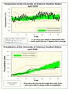
April 2008 Summary
The warmest April since 1991 with below average precipitation
April was over 2 degrees warmer than average making it the warmest April we have seen in the 10 year history of the UW weather station. Going back even further, I could find one year (1991) that was tied with this year and had to go back even further (1968) before I found one that was warmer.
After a very cold March that left lots of snow on the ground at the beginning of April, the switch really turned on the 17th with 9 of the next 10 days reaching a high above 20 degrees.
When the temperature went above 20 on April 17th at 4:00 pm we could declare Kimi Noguchi the winner of this year's UW weather station contest, I also liked his reason for choosing that date: "Based on my statistical knowledge, among all the available choices, I chose this date and time". Congratulations also go out to Stephen Drew and Carrie Warner, the second and third place winners.
April was the first below average month for precipitation since October of last year. We only had 53.8 mm compared to the average of 76.9 mm and only 10 mm fell during the last half on the month.
Even with this dry month, the wet start of the year means that we are still above average for 2008 with 320.3 mm so far, compared to the 264.4 mm we would expect.
As the conditions don't seem to be there for any snow in the short or long term forecast let's call an end to the 2007-2008 snowfall season. Thus we ended up with 257.5 cm breaking the previous record snowfall season of 245.3 cm in 1923-1924.
Environment Canada prediction of temperature for the month: Below average
Actual Temperature: Above average
Summary for April 2008:
Maximum Temperature 24.0 °C
Minimum Temperature -6.6 °C
Average Daily High Temperature 14.1 °C
(Long term average 11.2 °C)
Average Daily Low Temperature 2.1 °C
(Long term average 0.4 °C)
Total Precipitation 53.8 mm
(Long term average 76.9 mm)
(Long term averages based on 1970-2000 data for the Waterloo Wellington Airport)
Sign up to get the monthly weather station summary by e-mail
Subscribe to:
Posts (Atom)


