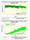
This was a month with two distinctly different parts; the first two thirds had slightly above average temperatures and a lot of sun (on the temperature graph you can see the large diurnal swing indicative of clear skies). During the last third of September the clouds came and the temperature generally went off a cliff (on the graph there is a lot more consistency in the daytime and nightime temperatures). Overall it was about a degree above average which is the highest for any month of this year.
Up until the last week of September it looked like it might have been an historically dry month, as there was no significant precipitation for the first 20 days. But then the wettest day of year came along (30.2 mm on the 28th) and although the total was still below average, it was no longer historically low.
This dry month brought the total precipitation for the year (700.3 mm) very close to the average (683.5 mm).
Summary for September 2009:
Maximum Temperature 24.7 °C
Minimum Temperature 1.9 °C
Average Daily High Temperature 21.0 °C (Long term average 20.0 °C)
Average Daily Low Temperature 9.6 °C (Long term average 8.3 °C)
Total Precipitation 51.4 mm (Long term average 87.5 mm)
(Long term averages based on 1971-2000 data for the Waterloo Wellington Airport)
Sign up to get the monthly weather station summary by e-mail


No comments:
Post a Comment