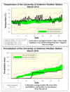
It was a very warm March with only 3 colder than average days, which all came at the end of the month. Overall it was 3.4 degrees above average, making it the warmest March since 2000 and the 6th warmest since records began in the region.
There wasn't that much precipitation overall with only 48.4 mm falling compared to an average of 70.6 mm. This continues the dry trend as we are only at 107.2 mm where we would expect 187.6 mm at this time of the year. A majority of the precipitation fell during a 3 day period between the 12th and the 14th.
But the big story is the lack of snowfall during the month, unfortunately it gets a bit difficult to directly compare to previous measurements, as the determination of snowfall amounts is a bit subjective. Although we didn't record any snow at the UW weather this March, the Environment Canada Waterloo-Wellington II station did have one day with 1.0 cm and another day with trace snowfall. You have to go back to 1946 when there were only 2 Trace amounts recorded to find a March that had less snow.
So I think we can safely say it was the lowest snowfall for March in over 60 years and at least very close to the lowest snowfall total as far as records go back in the area.
Summary for March 2010:
Maximum Temperature 17.3 °C
Minimum Temperature -13.0 °C
Average Daily High Temperature 7.9 °C (Long term average 3.5 °C)
Average Daily Low Temperature -3.3 °C (Long term average -5.6 °C)
Total Precipitation 48.4 mm (Long term average 70.6 mm)
(Long term averages based on 1971-2000 data for the Waterloo Wellington Airport)
Sign up to get the monthly weather station summary by e-mail


No comments:
Post a Comment