The high temperature only got up to 20.3°C on Thursday and the low on Friday morning went down to 7.5°C.
These were the coldest daytime high and nighttime low temperatures that we have seen in almost 2 months.
But of course a change is coming with 3 days of predicted highs over 30.
Friday, August 27, 2010
Tuesday, August 24, 2010
Get me a parka!
The high temperature was only 21.5°C on Monday making it the lowest daytime high temperature since July 1st.
Monday, August 23, 2010
Still a dry month
Even with the rain we had over the weekend (about 13 mm) we still have only seen about one third of the average amount of precipitation for the month with a little over a week left.
With the relatively wet June and July it doesn't look like most of the lawns around the area are really showing the effects of the dry August so far.
With the relatively wet June and July it doesn't look like most of the lawns around the area are really showing the effects of the dry August so far.
Monday, August 16, 2010
What does this thing do?
As this is Waterloo, odds are a lot of people can identify the image below. But for those that don't know, it is called a QR code. Basically it is a method of linking to a website without having to type out the URL. They are typically scanned in using smart phones which is why the QR code below links to the mobile version of the UW weather station site.

By the way, this was sent in by David Carr and I think it is a cool use of new technology.
So is this a useful addition to the UW weather station page? Is it big enough on the homepage? Is it too distracting?
Please leave any comments you have about it.
By the way, this was sent in by David Carr and I think it is a cool use of new technology.
So is this a useful addition to the UW weather station page? Is it big enough on the homepage? Is it too distracting?
Please leave any comments you have about it.
Tuesday, August 3, 2010
Northern light show on Wednesday and Thursday morning
Had a few emails about this, so here are the current estimates for the Northern Light show peaks: 2 am Wed, 1 pm Wed, 8 pm Wed, 2 am Thurs EDT. Remember it may or not be visible in our area and will be most visible outside of the city lights.
(do send along any pictures if you happen to see any)
Here is a good up to date place to find out what is happening:
http://spaceweather.com/
(do send along any pictures if you happen to see any)
Here is a good up to date place to find out what is happening:
http://spaceweather.com/
Sunday, August 1, 2010
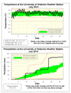
July 2010 Summary
A very hot July that was also very wet
It was very hot for the first week of the month and then it was just a bit hot for the rest. Overall it was a full 2 degrees above average and about 4 degrees hotter than what we saw last year in July.
The high temperature of 33.1 °C on the 5th was the warmest day since August 1st of 2007 and the 5 days in a row of temperatures over 30 (from the fourth to the eighth) was the first time that happened since 2005. On the night of the 5th (morning of 6th) the temperature only got down to 21.9 °C making it the warmest night since August 1st of 2006.
It was looking like a very average month for precipitation up until the morning of the 23rd, when we received over 35 mm between 7:45 am and 8:15 am. This was a 1 in 10 year precipitation event that caused some flooding in the area. At 65.2 mm it was also the wettest single day since July 11, 2008. (see some pictures of Silver Lake after the storm here: http://uwweatherstation.blogspot.com/2010/07/friday-mornings-significant-rain-event.html )
The total precipitation of 129.2 mm was definitely way above the average of 92.9 mm for the month, but not close to the record of 223.2 mm in 1988.
These last two very wet months have made up for the dry beginning to the year and we have now had the average precipitation for the first half of 2010.
Summary for July 2010:
Maximum Temperature 33.1 °C
Minimum Temperature 7.2 °C
Average Daily High Temperature 27.4 °C (Long term average 26.0 °C)
Average Daily Low Temperature 16.3 °C (Long term average 13.8 °C)
Total Precipitation 129.2 mm (Long term average 92.9 mm)
(Long term averages based on 1971-2000 data for the Waterloo Wellington Airport)
Sign up to get the monthly weather station summary by e-mail
Subscribe to:
Posts (Atom)


