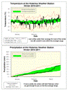
Overall the temperature was 0.6 degrees colder than average this winter, making it the coldest since 2005, but still within the average range. I think one reason it didn’t feel like a very cold winter was that it was never really cold for more than a few days in a row and the rest of the time it was just a few degrees below average. We also didn’t really see a mid-winter thaw, as between January 1st and February 13th it only went above zero for a single day.
For most of the winter the precipitation was very low, it wasn’t until late February that some very wet days put us back into the average range. The total precipitation was 220.4 mm compared to the average of 184.5 mm. This is almost double last year’s total of 113.2 mm, but not as much as the two years before that.
As always, it is hard to separate the snow during just the winter as opposed to the entire snowfall season. But, for just the winter we saw about 116 cm of snow compared to the average of 103 cm. However, it was really the 74 cm that came down in February that put us over the top.
Summary for Winter 2010/2011:
Maximum Temperature 13.6°C
Minimum Temperature -28.8°C
Average Daily High Temperature -1.8°C (Long term average -1.4°C)
Average Daily Low Temperature -10.6°C (Long term average -9.8°C)
Total Precipitation 220.4 mm (Long term average 184.5 mm)
(Long term averages based on 1971-2000 data for the Waterloo Wellington Airport)
Sign up to get the monthly weather station summary by e-mail


3 comments:
I enjoyed reading the Winter 2010/2011 summary. Hey Frank, do you think you could list the dates that the maximum and minimum temperatures occurred on? I don't remember the temperature getting up to 13.6 degrees this spring, although I remember it getting up to about 9.5 degrees. When I looked at the accompanying chart, I was greeted with some perplexing lines. The orange coloured lines labelled extreme temperatures, I assumed were indicative of the Winter 2010/2011's highest and lowest temperatures reached. But I quickly ruled that out, when I noticed the orange line's high temperature around March 5th, was about 24 degrees. So I guess the orange lines mean the highest and lowest temperatures recorded during many winters. The unidentified thick, black, line, I guessed, must be representative of the Winter 2010/2011's temperature ranges.
At least for Southern Ontario winter, I think it probably makes more sense to use the meteorological definition rather than the astronomical one.
The beginning of spring has been mostly dissapointing. After colder than average December, January, and February, starting the 2nd week of March, it started to look promising.
But the last week of March is sure to disappoint all those who have expected spring weather by this time of the year. Hopefully April will be much much better (something like April last year would be much welcomed :D )
Post a Comment