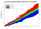
The only months that were significantly below average were June and July while all the spring and fall months were all very much above average. This included the wettest April ever, the fifth wettest May, and the third wettest October. The single day with the highest precipitation was November 29th with 52.1 mm.
In total there was 165.5 cm of snow during the calendar year of 2011, which is just a little more than the average of 159.5 cm. The biggest one day snowfall of 26 cm happened on March 24th, this was the snowiest day in 3 years.
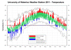
Overall the temperature for 2011 was a full degree above average putting it around the 14th warmest off all time. However, it is worth looking at how the temperature varied between the first and second half of the year. From January to June the temperature was half a degree colder than average while for July and December it was about 2.5 degrees warmer than average. Each month in the second half of the year it was more than 1.5 degrees warmer than average, making it the warmest July to December period ever seen in the region.
On January 23rd, the high temperature during the day of -16.6°C was the coldest daytime high since January 15th of 2004. The 35.7°C on July 21st was the highest temperature seen since August 8th, 2001 when it was 36.5°C. Note that this high temperature was actually recorded at the Waterloo-Wellington Airport as the UW weather station unfortunately had been vandalized and was not accurately reading temperature at this time.
On the morning of October 23rd at 4:45 am the temperature went below zero for the first time since the spring and thus the frost free season went from May 1st to October 22nd which is a total of 175 days. This was the longest frost free season since records began in the region in 1915, just beating out 1941 when there was a stretch of 174 days above zero.
Click on the image below to see the temperature chart:
Click on the image below to see the precipitation chart:


2 comments:
Great summary Frank! There is a typo in the written summary - weather extremes for "2010" should read "2011". I have all time record maxima and minima for Kitchener-Waterloo incorporating data from a former Kitchener weather station that closed around 1977. Shall I send you the data to incorporate into your extreme max/min chart?
Is this the thread for bitching about the lack of winter? Cuz we need that thread.
Post a Comment