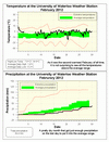
Sorry to keep repeating myself, but yet another very warm month that was 4.5 degrees higher than average. This makes it the second warmest February since records began in the area almost 100 years ago, and just a few tenths of a degree cooler than 1998 which was the warmest. This is now the 11th month in a row with above average temperatures.
It was the second warmest meteorological winter (Dec-Jan-Feb) just beating 2001-2002, but a full degree off of the record which was back in 1931-32. We will see how it stacks up against other astronomical winters in a few weeks.
It was the first month since August that we had less than average precipitation, but with 2.7 mm on the leap day of February 29th it put the month just barely into the average range.
Even with the warm weather the amount of snow that fell during the month (25 cm) was not that far below average (30.6 cm). The total for the snowfall season has been 76 cm which is a little less than half of the average total of 160 cm.
Summary for February 2012:
Maximum Temperature 7.8°C
Minimum Temperature -14.6°C
Average Daily High Temperature 1.4°C (Long term average –2.0°C)
Average Daily Low Temperature -5.2°C (Long term average -10.7°C)
Total Precipitation 34.4 mm (Long term average 51.3 mm)
(Long term averages based on 1971-2000 data for the Waterloo Wellington Airport)


2 comments:
Great job as always, but could you include standard deviations for things like temperature. You say it's 4.5 degrees warmer than average, but is that unusual?
What happened to the temperature data from Feb 3-7? Was there a groundhog on the loose? Love the site, keep up the great work!!!
Post a Comment