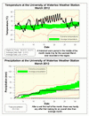
In the race for the warmest March ever in the region it wasn’t even in close. The previous record of 6.9 degrees warmer than average back in 1945 was eclipsed by this year’s 7.6 degrees. Although most of the month was warm, it was the historical one week period in the middle that really made this month unique. There were 7 days in a row of above 20 degrees, again beating 1945 when there were 4. The high temperature on the 22nd of 26.4°C was the warmest temperature ever seen during the month of March in the region, beating out March 26, 1945 when it was 26.1°C.
One last point, although 1998 was the warmest calendar year in the area, the warmest 12 month period was between March 1931 and February 1932, with an average temperature of 9.26°C. The second warmest was an average of 9.13°C between February 1931 and January 1932. Right now the past 12 months are third on the list with an average temperature of 9.11°C. By my calculations, if April is more than 1.6 degrees warmer than average, it will be the warmest 12 months on record in the region.
Kind of lost in the warm temperatures we have seen lately is the lack of precipitation since the beginning of the year. With 39.3 mm in March it was far below the average of 70.6 mm and the year to date is only 151.7 mm compared to the average of 189.9 mm.
Summary for March 2012:
Maximum Temperature 26.4°C
Minimum Temperature -14.0°C
Average Daily High Temperature 12.3°C (Long term average 3.3°C)
Average Daily Low Temperature -0.4°C (Long term average -5.8°C)
Total Precipitation 39.3 mm (Long term average 70.6 mm)
(Long term averages based on 1971-2000 data for the Waterloo Wellington Airport)


No comments:
Post a Comment