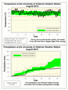
It was “only” 1.4 degrees warmer than average in August, making it the second “coldest” month this year (or at least the month that was second closest to the average). We actually had 4 days in a row where the daily high temperature was lower than the average, albeit not by that much, but still that hasn’t happened since early June.
The 48.1 mm of precipitation made it the third wettest month of the year, however it was still well below the average of 87.0 mm. It was actually decently wet for the first half of August, but then there was hardly anything for rest of the month.
The 402.9 mm of precipitation so far this year is still the second driest first 8 months of the year and much less than the average of 598.0 mm.
Summary for August 2012:
Maximum Temperature 32.7°C
Minimum Temperature 7.7°C
Average Daily High Temperature 26.2°C (Long term average 24.8°C)
Average Daily Low Temperature 14.1°C (Long term average 12.7°C)
Total Precipitation 48.1 mm (Long term average 87.5 mm)
(Long term averages based on 1971-2000 data for the Waterloo Wellington Airport)


2 comments:
I was just curious...how can the average range be outside of the extreme brackets (e.g. Aug '12 precipitation)? Are the extremes station specific while the averages are from Waterloo-Wellington?
From the Weather Station FAQ:
http://weather.uwaterloo.ca/info.html#FAQ
Q: On the monthly summary graphs, why do the extreme values sometimes cross into the average range? Logically this shouldn't happen.
A:The reason is that the averages are based on the Waterloo Wellington Airport data from 1970-2000 while the extreme values are for the 10 or so years of data we have from the UW weather station.
It is the standard in the meteorological field to use 30 years of data to create these averages. It is thought that this amount of time will eliminate the effects of short term fluctuations.
Post a Comment