A dry and colder (but still average) November
So that’s what a cold month feels like! However, overall it was just 0.2 degrees below average, as this is within the average range, November was not classified as a colder than average month. Thus it has still been 19 months since one of those, but it does break the streak of months when it was at least a bit warmer than average overall.
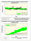
After two really wet months, November was really dry, in fact at 22.5 mm it was the 4th driest since records began in the region almost 100 years ago. As far as snow, we only had 2 cm which is much less than the 14 cm of a typical November.
With this dry month we are at 701.2 mm for the year compared to the average of 832.9 mm, this means (spoiler alert) that 2011 will most likely end up as a drier than average year overall. We would need around 150 mm for the month of December to get into the average range. This amount of precipitation has never happened before in December in this area.
Summary for November 2012:
Maximum Temperature 16.5°C
Minimum Temperature -6.5°C
Average Daily High Temperature 5.9°C (Long term average 6.1°C)
Average Daily Low Temperature -1.5°C (Long term average -1.4°C)
Total Precipitation 22.5 mm (Long term average 82.3 mm)
(Long term averages based on 1971-2000 data for the Waterloo Wellington Airport)


6 comments:
On November 24 at 2:05 AM, I recorded using a ruler from 10 different spots in the Ron Eydt Village Green, NW University of Waterloo Campus N2L 3G1, that the snow accumulation was 11.4 cm. Most of the snow had fallen in a four-hour period following 10 pm on November 23. I also sent a tweet to #snowtweets confirming this. Thus, I am surprised to see that the UW Columbia Lake weather station only recorded 2 cm of snow for the entire month. Even yesterday (Nov 30)'s snowfall on campus was about 1.5 cm. Nevertheless, the snow this season has fallen later than usual. However, I think we will likely see a cold and stormy season, owing partly to the dramatic Arctic ice melt in September. Dipole for everybody!
YW
1st-year Earth Science undergrad student, UW
There is no way that was only 2cm of snow for the entire month. Nov 23 was at least 5cm with up to 2cm on the 30th. ??
But the weather station measures melted precipitation. That does not have a direct translation to the depth of snow, does it?
Snow is measured by depth, not liquid equivalent.
The temperature in environment or in industries can be measured using Temperature Recorders
Unfortunately, snow depth is hard to measure with any consistency. I would be happy just to put the snow water equivalent numbers out but everybody wants to know about the snow depth.
At the time the summary was put out all the snow measurement locations were not available.
I have updated the value of snowfall to 6 cm for November 24th.
Post a Comment