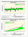
Although we have had some months that were slightly coder than average, they were still within what we define as the average range. At 1.3 degrees below average, it was the first month actually in the colder than average range since March of 2011. Although it was never very cold for more than a few days in a row, it was just a little bit colder than average a lot of days.
It was a very wet month with 97.5 mm of total precipitation which is almost double the average of 51.3 mm. It was only looking like a slightly higher than average month, but during the last 3 days when a major storm came through, it added another 32 mm to the total.
This was the second snowiest February since records began in the area in 1914, the total this year was 93 cm was only behind 1924 (132.6 cm) and was 3 times more than average.
It has also been really wet in the first two months of the year, at 212.2mm it is almost twice as much the average of 115.7 mm. Last year we didn’t get to that total until June 1st.
Summary for February 2013:
Maximum Temperature 4.9°C
Minimum Temperature -24.6°C
Average Daily High Temperature -2.6°C (Long term average –1.9°C)
Average Daily Low Temperature -12.4°C (Long term average -10.5°C)
Total Precipitation 97.5 mm (Long term average 51.3 mm)
(Long term averages based on 1971-2000 data for the Waterloo Wellington Airport)


No comments:
Post a Comment