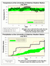
Although July finished off with a cold snap, this was offset by the very hot start making it a warmer than average month. Overall it was about a degree above average, but this was all because of the daily low temperatures that were 2 degrees above average, as the daily highs were very close to average.
A dramatic change in temperature occurred when a cold front moved through the area on the 19th bringing with it winds that caused a lot of damage from southern Ontario to Quebec. From 5:15 pm to 5:30 pm that day, the temperature dropped almost 9.5 degrees, this was the largest 15 minute temperature drop in the 15 year history of the UW weather station. Also interesting is that it only got down to 24.7 C the morning of the 19th. This would make it the one of the warmest nights on record, however as the temperature dropped that evening the official low for the day was less than 20. I will have to do some more digging to find the actual warmest night on record.
There were not that many days with precipitation in July, but when it happened, it really came down with 4 days over 30 mm resulting to a total of 173.1 mm for the month. This was almost double the average of 92.9 mm and the most since 1991 (when we had 182.6 mm).
This wet month puts the total for the year at 741.9 mm, well above the average for the end of July of 509.0 mm. This also makes it the second wettest first seven month of the year since records began in the region almost 100 years ago, only behind 1947 at 764.5 mm.
Summary for July 2013:
Maximum Temperature 32.6°C
Minimum Temperature 8.7°C
Average Daily High Temperature 26.1°C (Long term average 26.0°C)
Average Daily Low Temperature 15.9°C (Long term average 13.8°C)
Total Precipitation 172.1 mm (Long term average 92.9 mm)
(Long term averages based on 1971-2000 data for the Waterloo Wellington Airport)


6 comments:
There was quite an intense storm that went through Waterloo-Wellington over to Halton-Peel and tore down quite a few trees near the university. Does the weather station still have an anemometer? Would be interesting to see what the peak wind gusts were and how quickly the rain fell during that particular storm.
We have an anemometer but we are only able to record the average wind speed and not wind gusts at the moment. The highest average 15 minute speed was around 15 km/h which of course does not reflect any intense wind gusts that may have occurred. As for the rain we got about 4 mm in 45 minutes, which isn't all that intense compared to what we have seen the past few months.
I'm not sure how some warm days between the 14th and 19th of the month equates to a 'hot start to the month'. The 14th is no where near the start of the month. You might need more than one way to interpret your stats when the month begins with the first week plus as colder and ends the last week plus as colder but you're saying it was hot. Real hard to see July as a hot month when there were pretty much only 6 days with above average temps.
I'm surprised it came out the way it did, above average but I'm happy with that. The week long heatwave was very nice and the beginning was good too. The ending was awful and its still going. About the anemometer, I'd fix or replace it to measure gusts as a 15 minute average is nearly useless. That only tells you if the 15 min sector was windy or the whole day was.
You have to remember that we don't just look at the daily high temperatures but look at the temperature for the entire day to determine if it is a warm or cold day.
Thus, I disagree with the comment that "first week plus as colder", if you look at the graph you can see that the daily lows were quite a bit higher than average. Thus the only 4 of the first 20 days of the month were colder than average when you look at the entire day's temperatures.
Also the days between the 14th and 19th were not just "warm days", but they were very hot with the daily low temperature almost higher than average daily low.
Hi
Do you do school group tours of the weather station?
Karen
Post a Comment