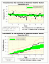
No other way to say it, that was a cold December. At 1.6 degrees less than average it was the coldest December since 2000 and the most below average for any month since January of 2011.
With 98.0 mm of precipitation for December, it was an above average month when compared to the average of 71.1 mm. It was the wet weekend that occurred around the ice storm that shot us from below to above average. In fact, those days might actually have been a bit wetter, as some of the “precipitation” that was measured once it got warm a few days after the ice storm was probably the result of ice falling from the sides of the sensor. But, with no evidence of this happening, all we can do is report the numbers as they came in and let people make their own interpretation.
The total snowfall for the month was 46.5 cm, this is a bit more than the average of 38.5 cm for December.
Summary for December 2013:
Maximum Temperature 12.4°C
Minimum Temperature -24.1°C
Average Daily High Temperature -2.3°C (Long term average -0.4°C)
Average Daily Low Temperature -8.8°C (Long term average -7.5°C)
Total Precipitation 98.0 mm (Long term average 71.1 mm)
(Long term averages based on 1971-2000 data for the Waterloo Wellington Airport)


3 comments:
It's definitely been cold. It'll be interesting to see how January turns out...
I would say that this January is also a record breaking cold month!
January is certainly going to much colder than average, however we will have to wait till the end to see about "record breaking"
Post a Comment