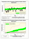
This was the second coldest March in the area since records began back in 1915, the coldest was back in 1960. Unlike February, this month we had a few breaks when the temperature went above zero, but of course most of the time it was well below average.
Overall, it was 5.6 degrees colder than average, this now makes it the most colder than average month in the history of the UW weather station, just surpassing last month. It is also quite the contrast to just 2 years ago when it was 7.6 degrees above average.
It was a very dry month with only 17.5 mm of precipitation, this means it was the 3rd driest March in the region. In a typical March we would get around 45 mm of rain and 24 cm of snow, this year we had 16.5 cm of snow and hardly any rain.
Summary for March 2014:
Maximum Temperature 10.9°C
Minimum Temperature -26.4°C
Average Daily High Temperature -1.0°C (Long term average 3.5°C)
Average Daily Low Temperature -12.4°C (Long term average -5.6°C)
Total Precipitation 17.5 mm (Long term average 70.6 mm)
(Long term averages based on 1971-2000 data for the Waterloo Wellington Airport)


2 comments:
I also noticed that there were a whopping six days in March when the low temperature was below -20. We haven't had even one day below -20 in the previous five Marches.
Hey UW Weather Station!
Have you heard the gospel of the Spring Indicator?
http://springindicator.com/
https://www.facebook.com/SpringIndicator
Not unlike the Weather station Contest, it seeks to find a somewhat qualitative start to the warm weather. The broom is implanted brush end up deep in a snowbank. Once it topples and touches bare grass, Spring is deemed to have begun!
Post a Comment