A very wet and hot September
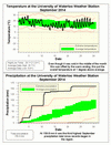
Despite a cold snap in the middle of September, the overall temperature was a little over a degree above average. This was a result of the really warm temperatures that ended the month which many thought it was the best week of the summer, which of course happened during the first week of autumn.
However, the real story of the month was the incredible amount of precipitation we saw. The average amount for the month was already surpassed by the 10th of September. The total of 159.8 mm was the third highest for the month of September in the 100 years of records in the region (behind 1986 at 216.6 mm and 175.3 mm in 1942). All this happened despite it being dry for the last 9 days of the month.
As a consequence of this very wet month the total for the year of 746.1 mm is now higher than the average for this time of year of 683.5 mm.
Summary for September 2014:
Maximum Temperature 29.1°C
Minimum Temperature 2.6°C
Average Daily High Temperature 20.7°C (Long term average 20.0°C)
Average Daily Low Temperature 9.9°C (Long term average 8.3°C)
Total Precipitation 159.8 mm (Long term average 87.5 mm)
(Long term averages based on 1971-2000 data for the Waterloo Wellington Airport)


4 comments:
No mention of the frost event on Fri Sept 19, 2014? Amongst other places throughout KW, there was frost on the UW rugby fields adjacent to Columbia Lake where the Weather Station is situated.
Even though there might have been colder temperatures in some low lying areas, the temperature at the UW weather station (and the Environment Canada station at the airport) did not go below zero. Thus based on the data we have it was not the first frost day.
So if I understand this correctly, the first day of frost is based solely on recorded temperature and not field conditions. If this assumption is correct, then it is plausible for the first "frost day" to occur with cloudy conditions and below freezing temperatures.
If this is the case, would you not agree that the parameters for considering the first "frost day" are rather skewed?
As we only have automatic equipment located at the standard height we have no way of accurately determining the field conditions (unless you are volunteering to be an on-site observer 24 hours a day).
I guess a better term to use would be "air frost" for what we measure at the UW weather station. See the full explanation as described in this article: http://about.metservice.com/our-company/learning-centre/frost/
Unfortunately we don't have the resources to set up a sensor to measure grass minimum temperature. I appreciate that frost may generally be seen on the ground before the temperature reaches zero at the temperature sensor. But all we can do is the best with the equipment we have.
Post a Comment