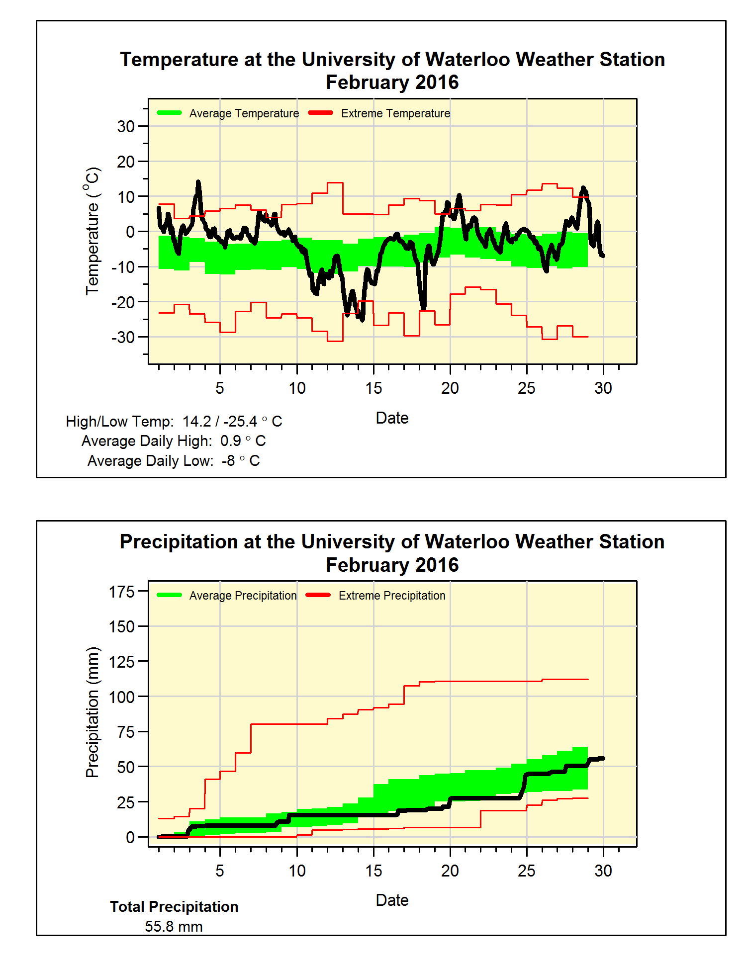
Another warm month with average precipitation
It was a month that saw some very warm and also some very
cold temperatures. However, the warms
ones greatly outnumbered the cold ones resulting in a month that was almost 2
degrees above the long term average.
This is a lot, but we only have to go back to 2012 to find a warmer one.
Of note is that the high of 14.2°C on the 3rd was
the highest February temperature we have ever seen in the over 100 years of
records in the region. This beat the
13.9°C on February 12th, 1999.
Not many large storms during the month, with the final total
precipitation of 55.8 mm ending up pretty close to the average of 54.9 mm. While the 17.5 cm of snow in February was
just a little over half of the average of 30.3 cm.
Summary for February 2016:
Maximum Temperature 14.2°C
Minimum Temperature -25.4°C
Average Daily High Temperature 0.9°C (Long term average
-1.2°C)
Average Daily Low Temperature -8.1°C (Long term average -9.7°C)
Total Precipitation 55.8 mm (Long term average 54.9 mm)
(Long term averages based on 1981-2010 data for the Waterloo
Wellington Airport)


3 comments:
Hey Frank, here's a somewhat interesting query/question for you. The total temperature range in February 2015 was almost 40 degrees (-25 to 14), have there been other months from other years with bigger ranges? Last month had to be on the high end of this...
Hi,
I'm just wondering if the average high of -0.9 was a typo, and should actually be +0.9? Your temperature graph lists +0.9 as the average high, and Environment Canada posted an average high of +1.1 for the month in Breslau. (http://climate.weather.gc.ca/climateData/dailydata_e.html?StationID=48569&timeframe=2&Year=2016&Month=2&cmdB1=Go#)
Yes the -0.9 was a typo (actually more of a carry over from January when it was 0.9), I have made the correction. Thanks.
Post a Comment