The hottest May on record with average precipitation
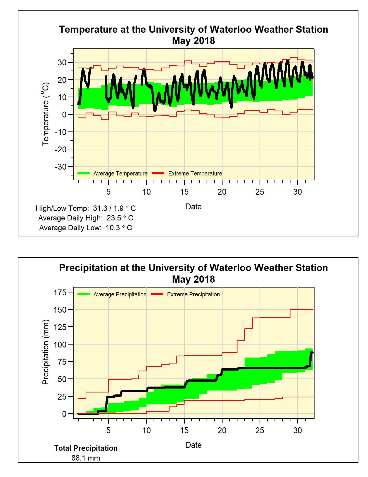
Well that was some weather whiplash! After April which was 4 degrees below average (the coldest in the history of the region) we just experienced a May that was almost 4.5 degrees above average. This was now the hottest May that we have seen in the local records which go back to 1915, beating 1991 by almost a full degree.
There were only 4 colder than average days during the month and it ended with a streak of 8 days above 25°C, something that has only happened one other time during May back in 1975. There were also 3 of those days above 30°C which has only happened about 5 times in our region (but how about 1962 when there were 5 days above 30°C in a row).
There were 2 really wet days with precipitation over 20 mm (the 4th and 31st) leading to a total for the month of 88.1 mm, a little over the average of 82.3 mm, but still within the average range. We have now had 409.6 mm of precipitation this year, a pretty good bit above the average of 340.2 mm for this time of the year.
Also, we didn’t have a temperature below zero during May, so that means the last one occurred on April 30. This is on the early end of the range of Apr 26 to May 23 we have seen in 20+ years of data at the UW Weather Station.
Summary for May 2018:
Maximum Temperature 31.3°C
Minimum Temperature 1.9°C
Average Daily High Temperature 23.5°C (Long term average 18.5°C)
Average Daily Low Temperature 10.3°C (Long term average 6.4°C)
Total Precipitation 88.1 mm (Long term average 82.3 mm)
(Long term averages based on 1981-2010 data for the Waterloo-Wellington Airport)


2 comments:
It was a slam dunk that this May was going to be like 1975 since this April was a match to that same year. Weather repeats in predictable sets like this. This must be the greatest swing in monthly temperatures recorded. That heatwave really bore & wore down since there was no transition time to acclimate from winter cold.
Often, when winter cold hangs on into April, or reappears in April, the transition to summer is very short and sudden, and the result is a warmer than average May. However, there are quite a few exceptions, where a considerably colder than normal May follows a chilly April - such as in 1995 and 1996. Springs like those made me start to wonder if summer would ever arrive kn those years.
Post a Comment