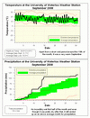
In the 10 year history of the UW weather station, the temperature in September has been the most above the average of any month and this year is no different. In total, 8 of the last 11 Septembers have been above average and the other 3 have been average with none below average (looking back the Environment Canada archive, 1993 was the last time we had a cold September). This year it was 1.6 degrees warmer than the standard average period of 1971-2000.
We were on a torrid pace during the first half of the month with 107.6 mm of precipitation by the 15th, however since then we have only had another 8.6 mm. This still puts us far above the average of 87.5 mm, but if we had doubled the first half total it would have been something to see.
With 862.9 mm of precipitation at the end of September, this is now the 5th wettest first 9 months of the year since record keeping began back in 1915.
Environment Canada prediction of temperature for the month: Average
Actual Temperature: Above average
Summary for September 2008:
Maximum Temperature 29.9 °C
Minimum Temperature 4.8 °C
Average Daily High Temperature 21.7 °C (Long term average 20.2 °C)
Average Daily Low Temperature 10.3 °C (Long term average 8.5 °C)
Total Precipitation 116.2 mm (Long term average 87.5 mm)
(Long term averages based on 1971-2000 data for the Waterloo Wellington Airport)Follow this link to see the graph showing the temperature and precipitation:
Sign up to get the monthly weather station summary by e-mail


No comments:
Post a Comment