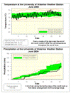
Even a streak of very hot days near the end couldn't prevent the month from being the coldest June since 2004. Overall, the daytime high temperatures were 1.5 degrees below average including 5 days that were colder than average by more than 5 degrees. It also got down to a frigid 2.9 °C on the morning of the 4th, this was the coldest June temperature since 1998.
A wet end to the month brought us back into the average range for precipitation after a dry start, the final total was 75.8 mm which isn’t too far below the average of 80.0 mm.
The total for the year so far is 485.2 mm compared to an average of 415.0 mm. Although we have had a lot of precipitation this year, it still only ranks as the 6th wettest year going back to 1971, so unless we kick up the pace it doesn't look like it will be an extreme year.
Environment Canada prediction of temperature for the month: Below average
Actual Temperature: Below average
Summary for June 2009:
Maximum Temperature 31.3 °C
Minimum Temperature 2.9 °C
Average Daily High Temperature 22.1 °C (Long term average 23.6 °C)
Average Daily Low Temperature 11.3 °C (Long term average 11.3 °C)
Total Precipitation 75.8 mm (Long term average 80.0 mm)
(Long term averages based on 1971-2000 data for the Waterloo Wellington Airport)
Sign up to get the monthly weather station summary by e-mail


No comments:
Post a Comment