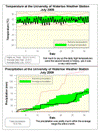
Wow, that was July? Really? Well yes it was and it was the second coldest July since records in the area began in 1915. That is when you consider the daily high temperatureswhere only July of 1992 was slightly colder (this year's average high temperatures were 22.6°C while it was only 22.2°C in 1992, compared to the average of 26.0°C). We only had 2 days this month where the high temperature was above average, so that makes 29 below average days.
The daily low temperatures came in at only 1.0 degrees below average which doesn't even rank in the top 10 (or bottom 10 depending on how you look at it) when looking at data since 1915.
By the way, lots of people said it felt like May or September, just want to go on record that even this cold July was warmer than an average May or September.
As I pointed out in my blog entry this month (see link below), the temperatures we have seen so far this year in Canada are unique in that it has been above average almost everywhere else in the world. In fact, the daily high temperatures for July in Whitehorse (and yes I know that's in Canada but it is a good example) were higher the ours, while in Texas they just recorded the hottest 30 days in their history, ever.
We had 17 days with some measured precipitation, which is a lot more than the average
of 10 days for July, this probably made it feel wetter than it actually was. As the total of 82.6 mm was still below the average of 92.9 mm, but close enough to be within the average range. There were only 2 days with over 10 mm of precipitation. While the total precipitation for the year so far is 567.8 mm compared to an average of 506.0 mm.
Usually I don't talk about the incoming solar radiation (a measure of how much of the sun's energy is getting to the surface), but a lot of people were saying that they never saw the sun this month. The only record we have of this is our own record at the UW weather station, so based on 10 years of data we were below the average, but back in 2004 there was even less incoming solar radiation so it wasn't historically low.
Summary for July 2009:
Maximum Temperature 26.0 °C
Minimum Temperature 8.4 °C
Average Daily High Temperature 22.6 °C (Long term average 26.0 °C)
Average Daily Low Temperature 12.6 °C (Long term average 13.8 °C)
Total Precipitation 82.6 mm (Long term average 92.9 mm)
(Long term averages based on 1971-2000 data for the Waterloo Wellington Airport)
Sign up to get the monthly weather station summary by e-mail


5 comments:
It may only be "average" precipitation but it seems like more because it always seems to fall on my kid's soccer game.
And the UpTown Waterloo Jazz Festival. Three out of the four times I've attended over the last decade have been rained on.
Is this just the vagaries of the weather gods?
Most people notice a lot of rain when it falls frequently on the weekends.
It would be interesting to see the frequency of precipitation on weekends, and compare that historically.
Have there been any poor air quality days this year? I can't remember any...when was the last time that happened?
This is what happens every once in a while when the jet stream is much further south than average. The last time this happened was during June-August 1992, when it seemed like we had 5 Mays or 5 Septembers, and only 1 day over 30 C that year.
Speaking of precip! What an interesting day Tuesday Aug. 4 was. Looks like about 20 mm for Waterloo near the universities, 40 mm closer to downtown Kitchener. I talked to a golf course superintendent at Port Credit faced with massive flooding caused by a 36 min downpour that dropped 76 mm! And then I hear from folk in the northern part of Waterloo who had nothing. Weird.
Post a Comment