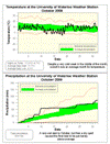
Just looking at the overall average temperature for the month it was about half a degree below average, this is still within the average range so it was officially an average month for temperature.
However, digging a bit deeper into the numbers, it was another month where there was a large difference between the daily high and low temperatures. The daily high temperatures were 1.5 degrees below average while the daily low temperatures were actually 0.4 degrees above average. As I have pointed out in the past, I’m of the belief that most people are more aware of the high temperature of the day and thus would have perceived October as a very cold month.
Looking at the graph of the temperature, you can really see the week between the 11th and the 17th where it was more than 5 degrees below average and how the temperature rebounded in the last half of the month. The first frost of the year happened on the evening of the 11th, a little later than the average date which is the first of the month.
During the first 10 or so days of the month it looked like we might be on track for a record wet October, but then almost 2 weeks of dry weather put in an end to that. A few storms in the last week put the total precipitation for the month at 84.4 mm, more than enough greater than the average of 67.1 mm to classify it as above average.
With the total precipitation for the year (784.7 mm) still close to the average (748.3 mm), it will take some pretty extraordinary numbers in these last couple of months of the year to get us out of the average range.
Summary for October 2009:
Maximum Temperature 17.2 °C
Minimum Temperature -4.7 °C
Average Daily High Temperature 11.7 °C (Long term average 13.2 °C)
Average Daily Low Temperature 3.2 °C (Long term average 2.9 °C)
Total Precipitation 84.4 mm (Long term average 67.1 mm)
(Long term averages based on 1971-2000 data for the Waterloo Wellington Airport)
Sign up to get the monthly weather station summary by e-mail


2 comments:
Hi Frank - t
I think there are two other reasons as to why October may be perceived to be colder than it actually was:
1. No spell of max temperatures of 20 or better. We usually get at least one such reading of 20 C or more in October. There was no Indian summer as a result.
2. September having consistently warm summerlike weather until the last week.
It's too bad the warm air and clear skies just before Halloween occurred at night. If this warm air had been here during the day, we probably would have been into the low 20s (similar to Windsor, Sarnia and even Goderich).
I looked in the records at Waterloo International Airport - the previous time we failed to reach 20 C in October (before this year) was October 1987 (19.4 C).
Post a Comment